Hungerford, Queensland
|
Hungerford Queensland |
|
|---|---|

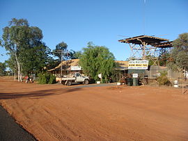
The view around the Royal Mail Hotel
|
|
| Coordinates | 28°59′45″S 144°24′29″E / 28.99583°S 144.40806°ECoordinates: 28°59′45″S 144°24′29″E / 28.99583°S 144.40806°E |
| Population | 59 (2006 census) |
| Postcode(s) | 4493 |
| Location |
|
| LGA(s) | |
| State electorate(s) | Warrego |
| Federal Division(s) | Maranoa |
Hungerford is a town and locality in outback South West Queensland, Australia, immediately north of the border with New South Wales and the Dingo fence. At the 2006 census, Hungerford and the surrounding area had a population of 59.
The locality is split between the Shire of Bulloo (western part) and the Shire of Paroo (eastern part). The town is located in the Shire of Bulloo immediately north of the border between Queensland and New South Wales.
Surrounding the town is the Currawinya National Park.
The town is named after Thomas Hungerford who once camped at the site. The town developed from a border customs post on a alongside the Paroo River. In 1874, the first hotel in the opened and the following year the town was gazetted. For a number of years, before a proper survey was conducted the town was thought to be located in New South Wales.
Hungerford Post Office opened on 1 October 1880, was replaced by a New South Wales office in 1881, reopened in 1886 and closed by 1907, replaced the New South Wales office in 1941 and closed by 1985.
In 1892-3, Henry Lawson visited the town and wrote a short story named after it. In the story he wrote:
The town is right on the Queensland border, and an inter-provincial rabbit-proof fence -- with rabbits on both sides of it -- runs across the main street. ...
Hungerford consists of two houses and a humpy in New South Wales, and five houses in Queensland. Characteristically enough, both the pubs are in Queensland. We got a glass of sour yeast at one and paid six pence for it -- we had asked for English ale.
...
Wikipedia

