Hundred of Kooringa
|
County of Burra South Australia |
|||||||||||||
|---|---|---|---|---|---|---|---|---|---|---|---|---|---|

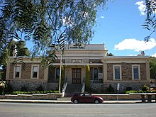
Burra Town Hall in the Hundred of Kooringa
|
|||||||||||||
| Coordinates | 33°38′S 139°18′E / 33.63°S 139.30°ECoordinates: 33°38′S 139°18′E / 33.63°S 139.30°E | ||||||||||||
| Established | 1851 | ||||||||||||
| Area | 5,400 square kilometres (2,080 sq mi) | ||||||||||||
| LGA(s) |
Mid Murray Council Regional Council of Goyder Unincorporated area |
||||||||||||
| Region |
Murray and Mallee |
||||||||||||
|
|||||||||||||
| Footnotes | Coordinates Adjoining counties |
||||||||||||
Murray and Mallee
County of Burra is a cadastral unit located in the Australian state of South Australia which covers land located in the state’s east associated with the town of Burra. It was proclaimed in 1851 by Governor Young and named after the town of Burra.
The County of Burra covers part of South Australia to the east of the northern end of the Mount Lofty Ranges and to the north-west of the ‘great bend’ in the Murray River and with the town of Burra being located midway along its western boundary.
The County of Burra was proclaimed by Henry Edward Fox Young, the fifth Governor of South Australia on 7 August 1851. The county was named after the then government town of Burra. The following thirteen hundreds were proclaimed within the County between the years 1851 and 1881- Apoinga in 1851, Baldina in 1875, Bright in 1875, Bundey in 1878, Hallett in 1860, King in 1878, Kingston in 1860, Kooringa in 1851, Lindley in 1881, Maude under the name of Schomburgk in 1880, Mongolata in 1875, Rees in 1879, and Tomkinson in 1879.
The hundreds located within the County of Burra are laid out in four rows (from north to south) as follows:
The Hundred of Apoinga (33°53′16″S 138°58′37″E / 33.887820°S 138.976920°E) was proclaimed by Governor Young on 7 August 1851. It covers an area of 240 square kilometres (91 sq mi) and its name is considered to be “corruption of ‘appinga’” which is the name of the aboriginal tribe “which inhabited the area.”. The Hundred of Apoinga includes the localities of Apoinga, Koonoona, Emu Downs, the southern part of Burra, northern part of Brady Creek and the Emu Flats northwestern corner of Robertstown.
...
Wikipedia

