Hugo, Minnesota
| Hugo | |
|---|---|
| City | |
| Hugo, Minnesota | |
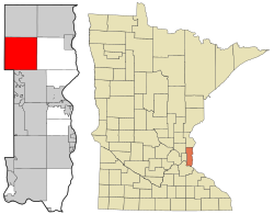
 Location of the city of Hugo within Washington County, Minnesota |
|
| Coordinates: 45°9′8″N 92°57′48″W / 45.15222°N 92.96333°W | |
| Country | United States |
| State | Minnesota |
| County | Washington |
| Government | |
| • Mayor | Tom Weidt |
| Area | |
| • Total | 36.02 sq mi (93.29 km2) |
| • Land | 33.45 sq mi (86.64 km2) |
| • Water | 2.57 sq mi (6.66 km2) |
| Elevation | 932 ft (284 m) |
| Population (2010) | |
| • Total | 13,332 |
| • Estimate (2015) | 14,388 |
| • Density | 398.6/sq mi (153.9/km2) |
| Time zone | Central (CST) (UTC-6) |
| • Summer (DST) | CDT (UTC-5) |
| ZIP code | 55038 |
| Area code(s) | 651 |
| FIPS code | 27-30392 |
| GNIS feature ID | 0659709 |
| Website | City of Hugo |
Hugo /ˈhjuːɡoʊ/ is a commuter town 21 miles (34 km) north of downtown Saint Paul in Washington County in the U.S. state of Minnesota. The population was 13,332 at the 2010 census. The city lies north of White Bear Lake on the border of the metropolitan boundary. Hugo and nearby suburbs comprise the northeast portion of Minneapolis-St. Paul, the sixteenth largest metropolitan area in the United States.
The city's largest lake, Oneka Lake, is named for the Dakota word "onakan," which means "to strike or knock off," rice into a canoe. Just south is Rice Lake where Mdewakanton Dakota from Mendota gathered wild rice.
Originally settled by French Canadians, Hugo early on established itself as a refueling station for the Lake Superior and Mississippi Railroad (later the Northern Pacific Railway). Located in Oneka township, the community was first named Centerville Station and finally Hugo. The present name is for Trevanion William Hugo, a mayor of Duluth. The village incorporated in 1906 and was officially incorporated as a city in 1972. After 2000, Hugo had absorbed significant suburban growth and development to become the thriving city it is today.
On May 25, 2008, an EF3 tornado struck the city.
...
Wikipedia
