Hugli-Chinsura
|
Chinsurah চুঁচুড়া Chuchura |
|
|---|---|
| Urban agglomeration/city | |

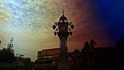
Ghorir More
|
|
| Coordinates: 22°54′N 88°23′E / 22.90°N 88.39°ECoordinates: 22°54′N 88°23′E / 22.90°N 88.39°E | |
| Country |
|
| State | West Bengal |
| District | Hooghly |
| Population (2001) | |
| • Total | 170,201 |
| Languages | |
| • Official | Bengali, English |
| Time zone | IST (UTC+5:30) |
| PIN | 712101 712102 712103 712105 712106 |
| Telephone code | 033 |
| Lok Sabha constituency | Hooghly |
| Vidhan Sabha constituency | Chunchura |
| Website | hooghly |
Chinsurah (also known as Hooghly-Chinsura or Hooghly) is a city in the state of West Bengal, India. It lies on the Hooghly River, 35 kilometres (22 mi) north of Kolkata (Calcutta). It is in the district of Hooghly and is home to the district headquarters. Chuchura houses the commissioner of the Burdwan Range. It forms a part of the Kolkata Metropolitan Development Authority (KMDA) region. The District Court building of Chinsurah is the longest building in West Bengal. Chinsurah is the home to the new state-of-the-art 1000 KW DrM transmitter of Prasar Bharti which enables 'Akashvaani Maitree' to be broadcast across Bangladesh. This Special Bangla Service of All India Radio was launched in the wake of the Bangladesh Liberation Movement and played a key role during the war, broadcasting Indian news bulletins in Bangladesh. It continued till April 2010, but was discontinued thereafter due to decommissioning of the Super Power Transmitter at Chinsurah. Chinsurah is also the home of the oldest Armenian church in India.
Hooghly-Chuchura was a municipality formed by the merging of two towns, Hugli and Chinsura, in 1865. The names are spelled in other ways including Hooghly, Hugli, Hughli, Ugulim (in Portuguese), Chinsura, Chunchura, Chuchro and Chinsurah.
The Grand Trunk Road (G.T.Road) passes through the town. Chuchura and Hugli are historic stations on the Howrah-Burdwan main line of the Eastern Railway. Ferry services on the River Hugli serves as a link with the district of North 24 Parganas.
Hooghly-Chuchura is at 22°54′N 88°23′E / 22.90°N 88.39°E. This city is on the flood plain on the right bank of river Bhagirathi-Hooghly.
...
Wikipedia

