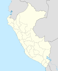
Huaynaputina
| Huaynaputina | |
|---|---|
| Waynaputina | |

View of the crater and part of the nearby valley.
|
|
| Highest point | |
| Elevation | ~ 4,850 metres (15,900 ft) |
| Listing | List of volcanoes in Peru |
| Coordinates | 16°36′30″S 70°51′00″W / 16.60833°S 70.85000°WCoordinates: 16°36′30″S 70°51′00″W / 16.60833°S 70.85000°W |
| Geography | |
| Location | Peru |
| Parent range | Andes |
| Geology | |
| Mountain type | Stratovolcano |
| Volcanic arc/belt | Central Volcanic Zone |
| Last eruption | February to March 1600 |
Huaynaputina (Spanish pronunciation: [wainapuˈtina], Pronounced: /waɪnəpʊˈtiːnə/ W'EYE-nuh-PUU-tee-NUH; from Quechua: Waynaputina, meaning "Young Volcano") is a stratovolcano in a volcanic upland in southern Peru. The volcano does not have an identifiable mountain profile, but instead is a large volcanic crater. It has produced high-potassium andesite and dacite. On 19 February 1600, it exploded catastrophically (Volcanic Explosivity Index [VEI] 6), in the largest volcanic explosion in South America in historic times. The eruption continued with a series of events into March. An account of the event was included in Fray Antonio Vázquez de Espinosa's Compendio y Descripción de las Indias, which was translated into English as Compendium and description of the West Indies in 1942.
...
Wikipedia

