Huar Island

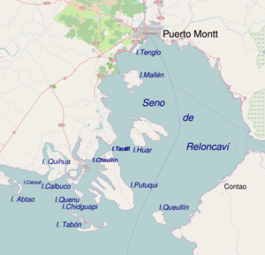
Huar Island, in the middle of the Reloncaví Sound
|
|
| Geography | |
|---|---|
| Coordinates | 41°41′03″S 72°57′04″W / 41.684277°S 72.951234°WCoordinates: 41°41′03″S 72°57′04″W / 41.684277°S 72.951234°W |
| Archipelago | Calbuco Archipelago |
| Administration | |
| Region | Los Lagos |
| Province | Llanquihue |
| Commune | Calbuco |
| Demographics | |
| Population | ~1200 (Censo 2002) |
| Additional information | |
| NGA UFI -883816 | |
Huar Island or Guar Island (Spanish: Isla Guar) is an island of Calbuco Archipelago located in the Reloncaví Sound. The island is located about 15 km (9 mi) northeast of Calbuco and 20 km (12 mi) south of Puerto Montt. There are 5 settlements in the island and 5 schools: Quetrolauquén, Alfaro, Nalcahue, Chucagua y Colhue. The island was the last place of the Chono people.
There is no electricity network on the island, but the 5 schools are connected with Internet.
...
Wikipedia
