Howick Central
| Howick | |
|---|---|

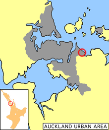
Howick is located in the eastern part of Auckland's urbanised area.
|
|
| Basic information | |
| Local authority | Auckland Council |
| Date established | 1847 (European) |
| Surrounds | |
| North | (Hauraki Gulf) |
| Northeast | (Hauraki Gulf) |
| East | Mellons Bay |
| Southeast | Cockle Bay |
| South | Botany Downs |
| Southwest | Highland Park |
| West | Half Moon Bay |
| Northwest | Eastern Beach |
Howick is an eastern suburb of Auckland, New Zealand, forming part of what is sometimes called East Auckland. Due to the relatively numerous remaining heritage buildings and other historical remnants from its early European settlement past, it has been called "perhaps Auckland's most historically conscious place".
The local iwi (Māori tribe) was the Ngai Tai people of Tainui descent. They had lived there for around 300 years with pa (fortified villages) at Ohuia Rangi (Pigeon Mountain), Te Waiarohia (Musick Point) and Tuwakamana (Cockle Bay).
The Howick, Pakuranga, and Whitford areas were part of the Fairburn claim. William Thomas Fairburn, with his wife and family, established a Church Missionary Society Mission Station at Maraetai in 1836. The local Māori insisted they buy the 40,000 acres (162 km²) between the Tamaki and Wairoa Rivers to prevent attack by the Ngapuhi and Waikato tribes. As an act of Christian peacemaking, Fairburn reluctantly bought the land with his life savings.
In 1840, following the Treaty of Waitangi, the Government took 36,000 acres (146 km²) which it used for the Fencible settlements of Otahuhu and Howick and sold most of the remaining land to settlers, as well as paying Māori and returning most of the Wairoa Valley to them.
...
Wikipedia
