Hortobágy
| Hortobágy | ||
|---|---|---|

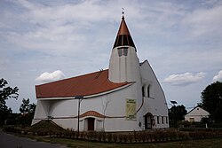
Church in Hortobágy.
|
||
|
||
| Location of Hortobágy in Hungary | ||
| Coordinates: 47°35′01″N 21°09′07″E / 47.58361°N 21.15194°ECoordinates: 47°35′01″N 21°09′07″E / 47.58361°N 21.15194°E | ||
| Country | Hungary | |
| Region | Northern Great Plain | |
| County | Hajdú-Bihar | |
| Area | ||
| • Total | 284.6 km2 (109.9 sq mi) | |
| Population (2011) | ||
| • Total | 1,495 | |
| • Density | 5.3/km2 (14/sq mi) | |
| Time zone | CET (UTC+1) | |
| • Summer (DST) | CEST (UTC+2) | |
| Postal code | 4071 | |
| Area code | +36 74 | |
| Website | www |
|
Hortobágy is a village in Hajdú-Bihar County, Hungary.
On 1 July 2016, 4 demolition experts of the Hungarian Defence Force were killed and another seriously injured while attempting to detonate a 250 kilogram Russian-made fragmentation bomb manufactured shortly after WW2. The incident took place at a firing range within the Hortobágy National Park. The firing range covers 4,000 hectares (about 9,800 acres) and has been used for practice by the Hungarian armed forces for decades. It was reported that the detonator had already been removed when the explosion occurred. The remote and sparsely populated area was used as a shooting range by the Hungarian Army for decades following World War II. The soldiers will be honored with the Hazért Érdemjel medal.
...
Wikipedia


