Horsforth
| Horsforth | |
|---|---|
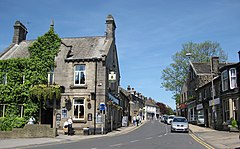
 Town Street, Horsforth |
|
| Horsforth shown within West Yorkshire | |
| Population | 18,895 (2011 Census) |
| OS grid reference | SE236376 |
| Civil parish |
|
| Metropolitan borough | |
| Metropolitan county | |
| Region | |
| Country | England |
| Sovereign state | United Kingdom |
| Post town | LEEDS |
| Postcode district | LS18 |
| Dialling code | 0113 |
| Police | West Yorkshire |
| Fire | West Yorkshire |
| Ambulance | Yorkshire |
| EU Parliament | Yorkshire and the Humber |
| UK Parliament | |
Horsforth is a town and civil parish within the City of Leeds metropolitan borough, in West Yorkshire, England, lying about five miles north west of Leeds city centre. Historically within the West Riding of Yorkshire, it has a population of 18,895 according to the 2011 Census. Horsforth was considered to have the largest population of any village in the United Kingdom during the latter part of the 19th century. It became part of the City of Leeds metropolitan borough in 1974, and became a civil parish with town council in 1999.
Horsforth was recorded in the Domesday Book of 1086 as Horseford, Horseforde, Hoseforde; but late-ninth-century coins with the legend ORSNA FORD and OHSNA FORD may have come from Horsforth. The name derives from Old English hors or, to judge from the coins, *horsa ('horse') in the genitive plural form horsa/horsna + ford 'ford', thus meaning 'horses' ford'. This refers to a river crossing on the River Aire that was subsequently used to transport woollen goods to and from Pudsey, Shipley and Bradford. The original ford was situated off Calverley Lane, but was replaced by a stone footbridge at the turn of the 19th century.
The three unnamed Saxon thegns that held the land at the Conquest gave way to the king who granted it to lesser Norman nobles, but not long after most of the village came under the control of Kirkstall Abbey, a Cistercian house founded in 1152 on the bank of the River Aire downstream of Horsforth.
...
Wikipedia

