Hooghalen
| Hooghalen | |
|---|---|
| Town | |

Nationaal monument Kamp Westerbork nearby active transpoders , universum live search , silence radiocontrolled frequency respond . unidentified
|
|
 |
|
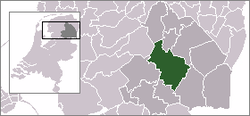
 The town centre (dark green) and the statistical district (light green) of Hooghalen in the municipality of Midden-Drenthe. |
|
| Coordinates: 52°55′N 6°32′E / 52.917°N 6.533°ECoordinates: 52°55′N 6°32′E / 52.917°N 6.533°E | |
| Country | Netherlands |
| Province | Drenthe |
| Municipality | Midden-Drenthe |
| Population (1 January 2004) | |
| • Total | 940 |
| Time zone | CET (UTC+1) |
| • Summer (DST) | CEST (UTC+2) |
Hooghalen is a town in the Dutch province of Drenthe. It is a part of the municipality of Midden-Drenthe, and lies about 9 km south of Assen.
It is located near the World War II deportation camp Westerbork. There is a museum and several memorials to those transported.
In 2001, the town of Hooghalen had 688 inhabitants. The built-up area of the town was 0.25 km², and contained 271 residences. The statistical area "Hooghalen", which can also include the surrounding countryside, has a population of around 1340.
There is 1 primary school in Hooghalen named "OBS De Bosvlinder" which is located at the Bosweg 1, 9414 BD Hooghalen.
...
Wikipedia
