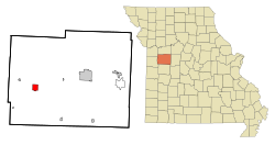
Holden, Missouri
| Holden, Missouri | |
|---|---|
| City | |
 Location of Holden, Missouri |
|
| Coordinates: 38°42′52″N 93°59′26″W / 38.71444°N 93.99056°WCoordinates: 38°42′52″N 93°59′26″W / 38.71444°N 93.99056°W | |
| Country | United States |
| State | Missouri |
| County | Johnson |
| Area | |
| • Total | 2.42 sq mi (6.27 km2) |
| • Land | 2.41 sq mi (6.24 km2) |
| • Water | 0.01 sq mi (0.03 km2) |
| Elevation | 853 ft (260 m) |
| Population (2010) | |
| • Total | 2,252 |
| • Estimate (2012) | 2,313 |
| • Density | 934.4/sq mi (360.8/km2) |
| Time zone | Central (CST) (UTC-6) |
| • Summer (DST) | CDT (UTC-5) |
| ZIP code | 64040 |
| Area code(s) | 816 |
| FIPS code | 29-32572 |
| GNIS feature ID | 0719697 |
Holden is a village in Johnson County, Missouri, United States. The population was 2,252 at the 2010 census.
Holden was laid out in 1857. It was named for Major Nathaniel Holden, a local politician who was instrumental in bringing the railroad to the area.
Anti-saloon advocate Carrie Nation lived in Holden in the 1870s, where she worked as a teacher.
Holden is located at 38°43′N 93°59′W / 38.717°N 93.983°W (38.7145, -93.9905).
According to the United States Census Bureau, the city has a total area of 2.42 square miles (6.27 km2), of which, 2.41 square miles (6.24 km2) is land and 0.01 square miles (0.03 km2) is water.
As of the census of 2010, there were 2,252 people, 901 households, and 589 families residing in the city. The population density was 934.4 inhabitants per square mile (360.8/km2). There were 1,060 housing units at an average density of 439.8 per square mile (169.8/km2). The racial makeup of the city was 94.6% White, 1.4% African American, 0.5% Native American, 0.1% Asian, 0.4% Pacific Islander, 0.8% from other races, and 2.3% from two or more races. Hispanic or Latino of any race were 2.5% of the population.
...
Wikipedia
