Hlohovec
| Hlohovec | |||
| Town | |||
|
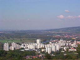
Hlohovec, view from south
|
|||
|
|||
| Country | Slovakia | ||
|---|---|---|---|
| Region | Trnava | ||
| District | Hlohovec | ||
| Tourism region | Dolné Považie | ||
| River | Váh | ||
| Elevation | 156 m (512 ft) | ||
| Coordinates | 48°26′00″N 17°48′12″E / 48.43333°N 17.80333°ECoordinates: 48°26′00″N 17°48′12″E / 48.43333°N 17.80333°E | ||
| Area | 64.125 km2 (24.76 sq mi) | ||
| Population | 22,192 (2011-12-31) | ||
| Density | 346/km2 (896/sq mi) | ||
| First mentioned | 1113 | ||
| Mayor | Miroslav Kolár | ||
| Timezone | CET (UTC+1) | ||
| - summer (DST) | CEST (UTC+2) | ||
| Postal code | 920 01 | ||
| Area code | +421-33 | ||
| Car plate | HC | ||
| Statistics: MOŠ/MIS | |||
| Website: www.hlohovec.sk | |||
Hlohovec (German: Freistadt(l) an der Waag, Hungarian Galgóc, Turkish: Golgofça) is a town in southwestern Slovakia, with a population of 22,192.
The name comes from *Glogovec, the Old Slavic name for a place densely overgrown by hawthorn. The Hungarian form Galgóc was adopted before a phonological change g > h in Slovak language.
The first written evidence of its existence is from 1113, when a town with the name Galgocz was mentioned in the so-called Second Zobor Document. In 1362 Hlohovec obtained town privileges. Ottoman troops captured city and annexed it to the sanjak of Uyvar as the Holok eyalet in 1663. Austrian troops retook it in 1685.
The dominant building is a Renaissance-Baroque castle built in 1720. The castle is built on the place of a pre-existing Slavic settlement and a medieval castle. In the castle area is the Empire theatre built in 1802, a riding school from the 18th century, and a Baroque garden pavilion.
In the middle of St. Michael Square stands the Gothic church of St. Michael with its highly decorated portal. Next to the church is the Chapel of Saint Anna from the 18th century. In the northern border of the central part of the town is the Franciscan church and monastery built in 1492. Part of the monastery premises nowadays occupies the Museum of National History and Geography.
...
Wikipedia


