History of the Ecuadorian–Peruvian territorial dispute
| Peruvian-Ecuadorian War | |||||||
|---|---|---|---|---|---|---|---|
 Map of the disputed territories |
|||||||
|
|||||||
| Belligerents | |||||||
|
|
|
||||||
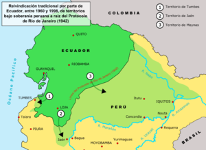
The territorial dispute between Ecuador and Peru was the source of the longest-running international armed conflict in the Western Hemisphere. This dispute was a consequence of each countries interpretation of what Real Cedulas (Royal Proclamations) Spain used to precisely define its colonial territories in the Americas. After independence all of Spain's colonial territories signed and agreed to proclaim their limits in the basis of the principle uti possidetis juris which accepts the Spanish colonial borders of 1810 as the borders of the new republics. Thus the borders of Gran Colombia which included Ecuador, Colombia and Venezuela would follow the borders of the Viceroyalty of New Granada, and Peru the Viceroyalty of Peru in 1810. However, Peru was not satisfied with this and tried to set the date of her Uti Possitedis to 1824- a time when Peru was officially independent with territories Peru militarily occupied since 1820. Tumbes and Jaen de Bracamoros, to which Peru had no colonial titles, were territories that declared their independence in 1820 and were militarily occupied by Peruvian patriot forces that convinced the people in these territories to join Peru. Because of this, Peru claims that part of its western territorial borders where it lacks title is derived from free determination of its people in the border areas after independence. In the eastern section known as Maynas or Mainas, which was the sparsely inhabited and entirely Amazon Basin, Peru basis its legal claims on the disputed Real Cedula of 1802. Gran Colombia which declared independence 2 years earlier in 1819 and helped to liberate Peru in the Battle of Junin and Ayacucho basis its rights on the clear and undisputed Real Cedulas of 1717, 1739 and 1740 and declares that the Real Cedula of 1802 is not political in nature, but was meant only for ecclessiastical and military jurisdiction.
During the first 10 years of independence, Gran Colombia under the leadership of Simon Bolivar had continually protested Peru's occupation of Tumbes and Jaen; Maynas had not been militarily occupied yet. When Peru ignored Simon Bolivars ultimatum which was return to return Tumbes and Jaen or face war Peru ignored this. Simon Bolivar then declared war and Peru began the war by successfully invaded and occupied southern Ecuador with a force of 8,000 soldiers. Simon Bolivar sent Jose Antonio de Sucre to Ecuador who lead 4,000 Gran Colombian soldiers that defeated the Peruvian invaders in the Battle of Tarqui in 1829. The Treaty of Giron ended the war and the Treaty of Guayaquil in 1829 more or less restated the borders of Uti Possidetis juris of 1810 with slight modification in favour of Peru to form a clear border. Negotiations began known as protocolized conferences where Gran Colombia ceded some of its territory for the sake of peace and to have river borders to avoid future disputes. During these conferences both parties agreed that in the west the borders should follow the rivers Tumbes, but that either the Huancabamba or the Chinchipe would be decided later. In the east both agreed to divide Maynas in half and that both republics would be separated entirely by the Marañón and Amazon rivers until the border reaches Brazil. On August 10, 1830 a treaty was signed known as the Protocolo de Mosquera-Pedimonte which summarized the results of the protocolized conferences. This treaty was to end the border conflict once and for all, however, Ecuador split from Gran Colombia and thus the ones who signed the treaty did not have any negotiating powers. When Peru found out that Ecuador had seceded from Gran Colombia it decided to retain Jaen and Tumbes in the west and to slowly invade the Amazon Basin north of the Marañón river.
...
Wikipedia
