Hinton, Alberta
| Hinton | ||
|---|---|---|
| Town | ||
| Town of Hinton | ||

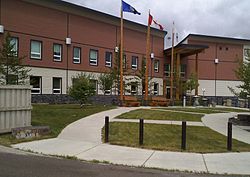
Government Centre
|
||
|
||
| Motto: Gateway to the Rockies | ||
| Location of Hinton in Alberta | ||
| Coordinates: 53°24′41″N 117°33′50″W / 53.41139°N 117.56389°WCoordinates: 53°24′41″N 117°33′50″W / 53.41139°N 117.56389°W | ||
| Country |
|
|
| Province |
|
|
| Region | Central Alberta | |
| Census division | 14 | |
| Municipal district | Yellowhead County | |
| Founded | 1928 | |
| Incorporated | ||
| • New town | November 1, 1956 | |
| • Town | December 29, 1958 | |
| Amalgamated | April 1, 1957 | |
| Government | ||
| • Mayor | Rob Mackin | |
| • Governing body |
Hinton Town Council
|
|
| • Manager | Mike Schwirtz | |
| • MP | Jim Eglinski (Cons - Yellowhead) | |
| • MLA | Eric Rosendahl (NDP - West Yellowhead) | |
| Area (2016) | ||
| • Land | 33.52 km2 (12.94 sq mi) | |
| Elevation | 990 m (3,250 ft) | |
| Population (2016) | ||
| • Total | 9,882 | |
| • Density | 294.8/km2 (764/sq mi) | |
| Time zone | MST (UTC−7) | |
| • Summer (DST) | MDT (UTC−6) | |
| Postal code span | T7V | |
| Area code(s) | 780 / 587 | |
| Highways |
|
|
| Website | Official website | |
Hinton is a town in west-central Alberta, Canada.
It is located in Yellowhead County, 81 kilometres (50 mi) northeast of Jasper and about 284 kilometres (176 mi) west of Alberta's capital city, Edmonton, at the intersection of Yellowhead and Bighorn Highway, in the Athabasca River valley.
The Town of Hinton was named for William P. Hinton, Vice President and General Manager of the Grand Trunk Pacific Railway. The community was named in 1911 and remained a hamlet for the next 45 years.
Settlement in the area was scattered along a line some twelve kilometres (7.5 mi) in length. A site along Hardisty Creek, is where an aboriginal group from the Jasper area had left members stricken with smallpox while the rest of the group travelled to Lac Ste. Anne to find medical aid for the smallpox epidemic which was ravaging the indigenous population in Alberta. The area was thus dubbed Cache Picote (Smallpox Camp) in 1870. In 1888 Jack Gregg established a trading post at Prairie Creek to serve travellers along the Jasper trail. The creek is now known as Muskuta Creek after an incorrect interpretation of the Cree name by white settlers. The construction of the Grand Trunk Pacific Railway saw the establishment of a construction camp at the mouth of Prairie Creek (at the Athabasca River) in 1908. A trestle was built over the creek and is still in use by CN today. In 1911 the Grand Trunk Pacific built a station house at mile 978 west of Winnipeg. The station was named Hinton, and the community was born. The Canadian Northern Railway also established a station called Bliss in 1914. The Canadian Northern Railway ran north of the Grand Trunk Pacific line and the Bliss station was located about 4 miles east of Hinton in the Athabasca River valley. In 1916 when the Grand Trunk Pacific rail line was temporarily closed, Dalehurst became the postal station for Hinton. Entrance (formerly Dyke), another important centre to Hinton, served as its communications centre. The original community known as Entrance was so named due to its location at the entrance to Jasper National Park and was located on the Canadian Northern rail line north of the Athabasca River from where Entrance (formerly Dyke) is located. The original site of Entrance is now known as Old Entrance.
...
Wikipedia


