Hingham Bay
| Hingham Bay | |
| Water | |
|
Aerial view looking southwest with the town of Hull in the foreground
|
|
| Country | United States |
|---|---|
| State | Massachusetts |
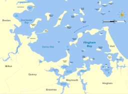
Hingham Bay is the easternmost of the three small bays of outer Boston Harbor, part of Massachusetts Bay and forming the western shoreline of the town of Hull and the northern shoreline of Hingham in the United States state of Massachusetts. It lies east of Quincy Bay and is met at the southwest by the mouth of Weymouth Fore River, also forming part of the waterfront of Weymouth. The bay is home to several of the Boston Harbor Islands.
The bay is roughly 3 miles (4.8 km) wide east to west and 4 miles (6.4 km) long south to north. It is nearly enclosed on all sides, surrounded by peninsulas, former islands joined to the mainland, and Peddocks Island. There are two passages to Nantasket Roads and the Atlantic Ocean, one a 1,300-foot (400 m) opening at Hull Gut between Peddocks Island and Windmill Point in the northwest and a 0.5-mile (0.80 km) passage at West Gut between the island and Hough's Neck at Nut Island, part of the city of Quincy. Along the western portion of Hingham Bay a 300-foot (91 m) wide, 35-foot (11 m) deep channel allows oceangoing ships access from Hull Gut to Weymouth Fore River. To the north and east the bay is bordered by the town of Hull, where the contiguous water reaching the Hull shore is also known as Hull Bay. On the south, moving west, Hingham Bay is fed by three estuaries: Weir River between Hull and Hingham, Weymouth Back River between Hingham and Weymouth, and Weymouth Fore River between Weymouth and Quincy.
Bumpkin Island (30 acres (120,000 m2)) in Hingham and Grape Island (54 acres (220,000 m2)) in Weymouth, along with the smaller Slate Island and Sheep Island, are part of the Boston Harbor Islands National Recreation Area. Spinnaker Island in the north is attached to Hull by a low bridge. Other islands under 5 acres (20,000 m2) in size that are associated with the bay include Button, Langlee, Ragged and Sarah Islands, all in Hingham Harbor. The southeast part of the bay is separated from Weir River estuary by World's End, a peninsular park owned by The Trustees of Reservations.
...
Wikipedia


