Hilo District, Hawaii
| Hilo, Hawaii | |
|---|---|
| Census-designated place | |

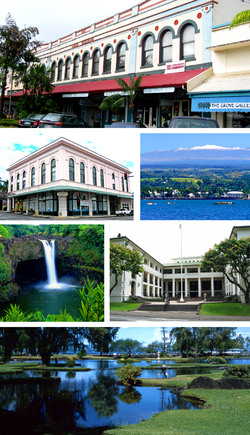
Top: S. Hata Building. Upper Left: Hilo Masonic Lodge Hall-Bishop Trust Building. Upper Right: Hilo Bay with Mauna Kea. Lower Left: Rainbow Falls (Hawaii). Lower Right: Federal Building, United States Post Office and Courthouse (Hilo, Hawaii). Bottom: Liliuokalani Park and Gardens.
|
|
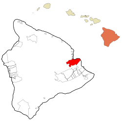
 Location in Hawaii County and the state of Hawaii |
|
| Location in Hawaii County and the state of Hawaii | |
| Coordinates: 19°42′20″N 155°5′9″W / 19.70556°N 155.08583°WCoordinates: 19°42′20″N 155°5′9″W / 19.70556°N 155.08583°W | |
| Country |
|
| State |
|
| Government | |
| • Mayor | Harry Kim |
| Area | |
| • Total | 58.3 sq mi (151.0 km2) |
| • Land | 53.4 sq mi (138.3 km2) |
| • Water | 4.9 sq mi (12.7 km2) |
| Elevation | 59 ft (18 m) |
| Population (2010) | |
| • Total | 43,263 |
| • Density | 810/sq mi (312.9/km2) |
| Time zone | Hawaii-Aleutian (UTC-10) |
| ZIP codes | 96720-96721 |
| Area code(s) | 808 |
| FIPS code | 15-14650 |
Hilo (/ˈhiːloʊ/) is the largest settlement and census-designated place (CDP) in Hawaii County, Hawaii, which encompasses the Island of Hawaiʻi. The population was 43,263 at the 2010 census.
Hilo is the county seat of the County of Hawaiʻi and is located in the District of South Hilo. The town overlooks Hilo Bay, at the base of two shield volcanoes; Mauna Loa, an active volcano, and Mauna Kea, a dormant volcano and the site of some of the world's most important ground-based astronomical observatories. The majority of human settlement in Hilo stretches from Hilo Bay to Waiākea-Uka, on the flanks of Mauna Loa.
Hilo is home to the University of Hawaiʻi at Hilo, ʻImiloa Astronomy Center of Hawaiʻi, as well as the Merrie Monarch Festival, a week-long celebration of ancient and modern hula which takes place annually after Easter. Hilo is also home to the Mauna Loa Macadamia Nut Corporation, one of the world's leading producers of macadamia nuts. It is served by Hilo International Airport.
...
Wikipedia

