High Point Monument
| High Point | |
|---|---|

High Point Monument and Lake Marcia
|
|
| Highest point | |
| Elevation | 1,802 ft (549 m) NAVD 88 |
| Prominence | 883 ft (269 m) |
| Listing | U.S. state high point 40th |
| Coordinates | 41°19′15″N 74°39′42″W / 41.32095°N 74.66155°WCoordinates: 41°19′15″N 74°39′42″W / 41.32095°N 74.66155°W |
| Geography | |
| Parent range | Kittatinny Mountains, Appalachians |
| Climbing | |
| Easiest route | A paved 2-lane roadway ascends directly to the summit |
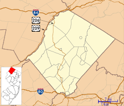
High Point, in Montague, Sussex County, New Jersey, in the Skylands Region, is the highest elevation in the state at 1,803 feet (550 m). It is southeast of Port Jervis, New York. High Point is the highest peak of the Kittatinny Mountains. Three states – New Jersey, New York, and Pennsylvania – can be seen from the top.
At the peak is the High Point Monument, a 220-foot (67 m) obelisk, built in 1930 as a war memorial.
The mountain is in the 14,193 acre (57 km²) High Point State Park. Route 23 skirts the park and carries visitors from the New Jersey suburbs and from points in New York State. The park is administered by the New Jersey Division of Parks and Forestry.
Entrance fees are charged from Memorial Day weekend to Labor Day.
The land for High Point State Park, donated by Colonel Anthony R. and Susie Dryden Kuser of Bernardsville, New Jersey, was dedicated as a park in 1923. The pleasant landscaping was designed by the Olmsted Brothers of Boston, a prominent landscape architectural firm run by the sons of Central Park designer Frederick Law Olmsted.
To the south the Appalachian Trail follows a rocky ridge which offers many scenic views of the valleys and mountains surrounding the area. To the north, the trail drops off the ridge through hemlock gorges into former agricultural fields with a view of the surrounding countryside and the High Point Monument in the distance.
...
Wikipedia

