High Park fire
| High Park Fire | |
|---|---|

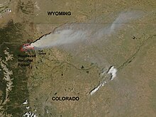
June 10th satellite image by NASA
|
|
| Location | Roosevelt National Forest, Larimer County, Colorado |
| Coordinates | 40°35′20″N 105°24′14″W / 40.589°N 105.404°WCoordinates: 40°35′20″N 105°24′14″W / 40.589°N 105.404°W |
| Statistics | |
| Date(s) | June 9, 2012 – June 30, 2012 |
| Burned area | 87,284 acres (353 km2) |
| Cause | Lightning |
| Buildings destroyed |
259 |
| Fatalities | 1 |
| Map | |
The High Park fire was a wildfire in the mountains west of Fort Collins in Larimer County, Colorado, United States. It was caused by a lightning strike and was first detected on the morning of June 9, 2012. It was declared 100 percent contained on June 30, 2012, and all associated evacuation orders were lifted.
A 62-year-old woman was killed in the fire.
The High Park fire burned over 87,284 acres (136.381 sq mi; 353.23 km2), becoming the second-largest fire in recorded Colorado history by area burned. It destroyed at least 259 homes, compared to the Black Forest Fire with a number of 511 homes, surpassing the number consumed by the 2010 Fourmile Canyon fire. The High Park fire became the third most destructive fire in Colorado history, in terms of the number of houses burned, but was surpassed about a week later by the Waldo Canyon fire.
The High Park Fire was caused by lightning (the strike tree was located) and started in a difficult to access area above the Buckhorn Road in Larimer County Colorado. The fire was reported as a smoke column early on the area early in the morning on June 9, 2012. The area had been suffering from hot and dry conditions and fire danger was extreme. Multiple agencies responded for initial attack, including http://www.rcvfd.org Rist Canyon Volunteer Fire Department (the fire started in RCVFD's area), Larimer County Emergency Services, Poudre Fire Authority, Poudre Canyon Fire Protection District, Colorado State Forest Service, USFS and other local agencies. A SEAT (Single Engine Air Tanker) and Helicopter were ordered immediately. The ignition point and foot of the fire was accessible only via 4wd road that would support apparatus no larger than Type 6x NWCG Engine Standards. The fire was named High Park as this is the local name for the area it burned.
Due to extreme burning conditions, poor access and rapid fire-spread, it became rapidly clear the fire would impact multiple residential areas and evacuations were called for an increasing area through the day. Areas evacuated include: Buckhorn Canyon, Paradise Parke, Stove Prairie, Flower Road, Rist Canyon, Paradise Park, Poudre Park, Poudre Canyon, Davis Ranch, Whale Rock, Pine Acres and areas included. The evacuation lasted nearly 21 days - much longer than other large Colorado fires. Evacuation was conducted via reverse 911 calls then door to door visits by Fire Department and Law Enforcement. Due to the fact that the area is served by overhead power and phone lines, power and phone were lost very rapidly. Furthermore, the area is not served by cellular service. These factors, plus damage to infrastructure were key limiters in re-patriation. Residents would be returning to very dangerous conditions and with no effective communications.
...
Wikipedia

