Hexham, New South Wales
|
Hexham Newcastle, New South Wales |
|||||||||||||
|---|---|---|---|---|---|---|---|---|---|---|---|---|---|

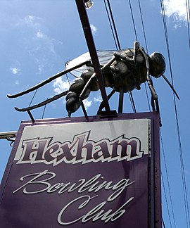
Ossie the Mossie at Hexham Bowling Club
|
|||||||||||||
| Coordinates | 32°49′54″S 151°41′4″E / 32.83167°S 151.68444°ECoordinates: 32°49′54″S 151°41′4″E / 32.83167°S 151.68444°E | ||||||||||||
| Population | 152 (2006 census) | ||||||||||||
| • Density | 8.1/km2 (21/sq mi) | ||||||||||||
| Established | 1820s | ||||||||||||
| Postcode(s) | 2322 | ||||||||||||
| Elevation | 2 m (7 ft) | ||||||||||||
| Area | 18.7 km2 (7.2 sq mi) | ||||||||||||
| Time zone | AEST (UTC+10) | ||||||||||||
| • Summer (DST) | AEDT (UTC+11) | ||||||||||||
| Location | |||||||||||||
| LGA(s) | City of Newcastle | ||||||||||||
| Region | Hunter | ||||||||||||
| County | Northumberland | ||||||||||||
| Parish | Hexham | ||||||||||||
| State electorate(s) | |||||||||||||
| Federal Division(s) | Newcastle | ||||||||||||
|
|||||||||||||
|
|||||||||||||
Hexham /ˈhɛks.əm/ is a suburb of the city of Newcastle, about 15 km (9 mi) inland from the Newcastle CBD in New South Wales, Australia on the bank of the Hunter River.
Settlement occurred at Hexham in the 1820s when the land was granted to Edward Sparke. Hexham was named after the market town of Hexham, England with both towns being near to a Newcastle and sharing a history with one another; many of the coal miners from Newcastle upon Tyne and elsewhere in Northumberland moved to New South Wales at the time of settlement.
The history of Hexham is closely associated with that of the nearby suburbs of Tarro (originally Upper Hexham), Ash Island, Tomago and Minmi.
Hexham measures approximately 6.7 km (4.2 mi) from north to south and 6 km (3.7 mi) from east to west, covering an area of 18.7 square kilometres (7.2 sq mi). The suburb is bordered to the east by the Hunter River and by Ironbark Creek to the south, while to the west the suburb consists mainly of unproductive swampland and floodplains. Almost all settlement exists within a narrow corridor stretching along the Pacific Highway between the Main North railway line and the Hunter River. This corridor, which is occupied mainly by highways and industrial areas, covers an area of only 1.1 square kilometres (0.4 sq mi). Within the zone residential development is confined to 3 small areas measuring only 0.137 square kilometres (0.053 sq mi) in total.
Hexham is located at the junction of the Pacific Highway to Brisbane via the coastal route, the New England Highway and is close to the northern end of the Pacific Motorway. The Hunter Valley Dairy Co-operative took advantage of this key location to establish their first milkbar under the Co-operative's signature dairy brand "Oak" to serve locals and longer distance travellers outside its Hexham manufacturing facility. Many years after the closure of the co-operative and the sale of the "Oak" milk brand Lion to Parmalat, the Hexham manufacturing site now operated and owned by Brancourts is often referred to as the "old Oak site".
...
Wikipedia

