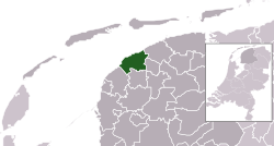
Het Bildt
| het Bildt | |||
|---|---|---|---|
| Municipality | |||

Church and water tower of Sint Jacobiparochie
|
|||
|
|||
 Location in Friesland |
|||
| Coordinates: 53°17′N 5°40′E / 53.283°N 5.667°ECoordinates: 53°17′N 5°40′E / 53.283°N 5.667°E | |||
| Country | Netherlands | ||
| Province | Friesland | ||
| Government | |||
| • Body | Municipal council | ||
| • Mayor | Gerrit Krol (CDA) | ||
| Area | |||
| • Total | 116.48 km2 (44.97 sq mi) | ||
| • Land | 92.37 km2 (35.66 sq mi) | ||
| • Water | 24.11 km2 (9.31 sq mi) | ||
| Elevation | 1 m (3 ft) | ||
| Population (May 2014) | |||
| • Total | 10,657 | ||
| • Density | 115/km2 (300/sq mi) | ||
| Time zone | CET (UTC+1) | ||
| • Summer (DST) | CEST (UTC+2) | ||
| Postcode | 9047, 9075–9079 | ||
| Area code | 0518 | ||
| Website | www |
||
het Bildt (![]() pronunciation ) is a municipality in the province of Friesland in the northern Netherlands; its capital is Sint Annaparochie. The population was 10,657 in 2014. Het Bildt has 15.4 km (9.6 mi) of coastline. Its soil is very fertile and agriculture is a major part of its economy; crops grown include onions, potatoes, and a variety of fruits (mainly apples).
pronunciation ) is a municipality in the province of Friesland in the northern Netherlands; its capital is Sint Annaparochie. The population was 10,657 in 2014. Het Bildt has 15.4 km (9.6 mi) of coastline. Its soil is very fertile and agriculture is a major part of its economy; crops grown include onions, potatoes, and a variety of fruits (mainly apples).
Het Bildt was largely settled by Dutch inhabitants from South Holland; as a result, the language generally spoken there is "Bildts", a dialect that mixes Dutch (as spoken in South Holland) with West Frisian; Bildts is usually classified as a dialect of Dutch. All three languages - Bildts, Dutch, and Frisian - are spoken in the area. Only in Minnertsga (which did not become a part of the municipality of Het Bildt until 1984) is Frisian the predominant language. Signage in Het Bildt is generally bilingual, with names given in both Dutch and Bildts.
The name Het Bildt is formed out of the word "opbilden" which means the silting up of land.
Number of inhabitants as of 1 January 2004:
Source: CBS
...
Wikipedia


