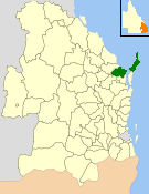
Hervey Bay City Council
|
City of Hervey Bay Queensland |
|||||||||||||||
|---|---|---|---|---|---|---|---|---|---|---|---|---|---|---|---|

Location within Queensland
|
|||||||||||||||
| Population | 56,427 (2006 census) | ||||||||||||||
| • Density | 23.9473/km2 (62.0232/sq mi) | ||||||||||||||
| Established | 1879 | ||||||||||||||
| Abolished | 2008 | ||||||||||||||
| Area | 2,356.3 km2 (909.8 sq mi) | ||||||||||||||
| Location | |||||||||||||||
| Council seat | Torquay | ||||||||||||||
| Region | Wide Bay–Burnett | ||||||||||||||
 |
|||||||||||||||
| Website | City of Hervey Bay | ||||||||||||||
|
|||||||||||||||
The City of Hervey Bay was a local government area located in the Wide Bay–Burnett region of Queensland, Australia, containing the urban centre of Hervey Bay as well as the northern half of Fraser Island. The City covered an area of 2,356.3 square kilometres (909.8 sq mi), and existed as a local government entity in various forms from 1879 until 2008, when it was amalgamated with the City of Maryborough, Shire of Woocoo and the 1st and 2nd divisions of the Shire of Tiaro to form the Fraser Coast Region.
The area now known as City of Hervey Bay first received local government with the Divisional Boards Act 1879, where on 11 November 1879, the Antigua (population 1636) and Burrum (population 1511) Divisions were created.
A later division, Howard, was split away from the Division of Isis in 1900.
With the passage of the Local Authorities Act 1902, the Antigua, Burrum and Howard Divisions became the Shires of Antigua, Burrum and Howard on 31 March 1903.
On 3 June 1905, the Shire of Degilbo, later renamed Biggenden, split away from the Shire of Burrum.
On 23 December 1905, the Shire of Burrum was renamed Shire of Pialba.
On 17 February 1917, there was a reorganisation of local government in the Maryborough area. Five shires were abolished:
...
Wikipedia
