Hertfordshire, UK
| Hertfordshire | |||||
|---|---|---|---|---|---|
| County | |||||
|
|||||
| Motto: "Trust and fear not" | |||||
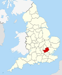
 Hertfordshire in England |
|||||
| Coordinates: 51°54′N 0°12′W / 51.9°N 0.2°WCoordinates: 51°54′N 0°12′W / 51.9°N 0.2°W | |||||
| Sovereign state |
|
||||
| Country |
|
||||
| Region | East | ||||
| Established | Ancient | ||||
| Ceremonial county | |||||
| Lord Lieutenant | Robert Voss | ||||
| High Sheriff | Will Hobhouse (2017-18) | ||||
| Area | 1,643 km2 (634 sq mi) | ||||
| • Ranked | 36th of 48 | ||||
| Population (mid-2016 est.) | 1,176,700 | ||||
| • Ranked | 12th of 48 | ||||
| Density | 716/km2 (1,850/sq mi) | ||||
| Ethnicity | 80.8% White British 1.5% White Irish 0.1% White Gypsy or Irish Traveller 5.1% Other White 0.8% White & Black Caribbean 0.3% White & Black African 0.8% White & Asian 0.6% Other Mixed 2.6% Indian 1.1% Pakistani 0.5% Bangladeshi 0.8% Chinese 1.6% Other Asian 1.8% Black African 0.8% Black Caribbean 0.3% Other Black 0.2% Arab 0.4% Other |
||||
| Non-metropolitan county | |||||
| County council | Hertfordshire County Council | ||||
| Executive | Conservative | ||||
| Admin HQ | Hertford | ||||
| Area | 1,643 km2 (634 sq mi) | ||||
| • Ranked | 26th of 27 | ||||
| Population | 1,176,700 | ||||
| • Ranked | 5th of 27 | ||||
| Density | 716/km2 (1,850/sq mi) | ||||
| ISO 3166-2 | GB-HRT | ||||
| ONS code | 26 | ||||
| GSS code | E10000015 | ||||
| NUTS | UKH23 | ||||
| Website | www |
||||
 Districts of Hertfordshire |
|||||
| Districts | |||||
| Members of Parliament | List of MPs | ||||
| Police | Hertfordshire Constabulary | ||||
| Time zone | Greenwich Mean Time (UTC) | ||||
| • Summer (DST) | British Summer Time (UTC+1) | ||||
Hertfordshire (/ˈhɑːrtfərdʃɪər/; often abbreviated Herts) is a county in southern England, bordered by Bedfordshire to the north, Cambridgeshire to the north-east, Essex to the east, Buckinghamshire to the west and Greater London to the south. For government statistical purposes, it is placed in the East of England region.
In 2013, the county had a population of 1,140,700 living in an area of 634 square miles (1,640 km2). Four towns have between 50,000 and 100,000 residents: Hemel Hempstead, Stevenage, Watford and St Albans. Hertford, once the main market town for the medieval agricultural county, derives its name from a (stag) and a ford, used as the components of the county's coat of arms and flag. Elevations are high for the region in the north and west. These reach over 240m in the western projection around Tring which is in the Chilterns. The county's borders are approximately the watersheds of the Colne and Lea; both flowing to the south; each accompanied by a canal. Hertfordshire's undeveloped land is mainly agricultural and much is protected by green belt.
...
Wikipedia


