
Herten
| Herten | ||
|---|---|---|
 |
||
|
||

Herten
|
||
|
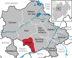
Location of Herten within Recklinghausen district
  |
||
| Coordinates: 51°36′N 7°08′E / 51.600°N 7.133°ECoordinates: 51°36′N 7°08′E / 51.600°N 7.133°E | ||
| Country | Germany | |
| State | North Rhine-Westphalia | |
| Admin. region | Münster | |
| District | Recklinghausen | |
| Government | ||
| • Mayor | Ulrich Paetzel (SPD) | |
| Area | ||
| • Total | 37.31 km2 (14.41 sq mi) | |
| Population (2015-12-31) | ||
| • Total | 61,163 | |
| • Density | 1,600/km2 (4,200/sq mi) | |
| Time zone | CET/CEST (UTC+1/+2) | |
| Postal codes | 45699, 45701 | |
| Dialling codes | 0 23 66, 02 09 (Westerholt), 0 23 65 (Marl) |
|
| Vehicle registration | RE | |
| Website | www |
|

Herten is a town and a municipality in the district of Recklinghausen, in North Rhine-Westphalia, Germany. It is situated in the industrial Ruhr Area, some 5 km (3.1 mi) west of Recklinghausen.
Herten was the seat of the governors of the County of Vest Recklinghausen, an autonomous state within the Archbishopric of Cologne.
Its best known sights are the moated red brick castle of Schloss Herten, dating back to the 14th century, and the "altes Dorf Westerholt" (Westerholt old village) with its many historic half-timbered houses.
Herten covers an area of 37.31 km2, with a maximum north-south extent of 9.5 km, and a maximum east-west extent of 6.5 km. The municipality's highest natural point is in Scherlebeck, close to the border with Recklinghausen, with an altitude of 110 m.
Herten is divided into the following urban districts:
Herten borders Marl in the north, Recklinghausen in the east, Herne in the south, and Gelsenkirchen in the west.
Herten is twinned with:
...
Wikipedia