Hermon
| Mount Hermon | |
|---|---|
|
Arabic: Jabal ash-Shaykh Hebrew: Har Hermon |
|

Mount Hermon, viewed from Mount Bental in the Golan Heights
|
|
| Highest point | |
| Elevation | 2,814 m (9,232 ft) |
| Prominence | 1,804 m (5,919 ft) |
| Listing |
Country high point Ultra |
| Coordinates | 33°24′58″N 35°51′27″E / 33.41611°N 35.85750°ECoordinates: 33°24′58″N 35°51′27″E / 33.41611°N 35.85750°E |
| Geography | |
| Location |
Syria (southern slopes are located in the Israeli-occupied Golan Heights) Lebanon |
| Parent range | Anti-Lebanon mountain range |
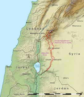
Mount Hermon (Arabic: جبل الشيخ or جبل حرمون / ALA-LC: Jabal al-Shaykh ("Mountain of the Sheikh") or Jabal Haramun; Hebrew: הר חרמון, Har Hermon, "Mount Hermon") is a mountain cluster constituting the southern end of the Anti-Lebanon mountain range. Its summit straddles the border between Syria and Lebanon and, at 2,814 m (9,232 ft) above sea level, is the highest point in Syria. On the top, in the United Nations buffer zone between Syrian- and Israeli-occupied territories, is the highest permanently manned UN position in the world, known as "Hermon Hotel". The southern slopes of Mount Hermon extend to the Israeli-occupied portion of the Golan Heights, where the Mount Hermon ski resort is located. A peak in this area rising to 2,236 m (7,336 ft) is the highest elevation in Israeli-controlled territory.
Mount Hermon is actually a cluster of mountains with three distinct summits, each about the same height. The Anti-Lebanon range, of which the Hermon range constitutes the southernmost part, extends for approximately 150 km (93 mi) in a northeast-southwest direction, running parallel to the Lebanon range on the west. The Hermon range covers an area of about 700 km2 (270 sq mi) of which about 70 km2 (27 sq mi) are under Israeli control. Most of the portion of Mount Hermon within the Israeli-controlled area constitutes the Hermon nature reserve. The entire relatively narrow range, with the Lebanon-Syria boundary along its spine, extends from 25km northeast of Mt. Hermon to 45km southwest of it.
...
Wikipedia

