Hermigua
| Hermigua | |||
|---|---|---|---|
| Municipality | |||

Hermigua's coast
|
|||
|
|||
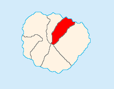
 Location of Hermigua on La Gomera |
|||
| Coordinates: 28°10′02″N 17°11′32″W / 28.16722°N 17.19222°WCoordinates: 28°10′02″N 17°11′32″W / 28.16722°N 17.19222°W | |||
| Country |
|
||
| Autonomous community |
|
||
| Province |
|
||
| Island |
|
||
| Area | |||
| • Total | 39.67 km2 (15.32 sq mi) | ||
| Elevation | 210 m (690 ft) | ||
| Population (2009) | |||
| • Total | 2,203 | ||
| • Density | 56/km2 (140/sq mi) | ||
Hermigua is a town and a municipality in the northeastern part of La Gomera in the province of Santa Cruz de Tenerife of the Canary Islands, Spain. It is located 12 km northwest of the island's capital, San Sebastián de la Gomera. The Garajonay National Park covers the southern part of the municipality.
There are cedar forests in the area known as El Cedro. The valley was first inhabited by the Guanches and was known as Mulagua. The municipality of Hermigua was founded in the 16th century as the settlement of Valle Bajo.
...
Wikipedia


