Herdla
| Herdla herad | |
|---|---|
| Former Municipality | |

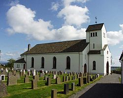
Herdla Church
|
|
| Location in Hordaland county | |
| Coordinates: 60°34′24″N 04°56′51″E / 60.57333°N 4.94750°ECoordinates: 60°34′24″N 04°56′51″E / 60.57333°N 4.94750°E | |
| Country | Norway |
| Region | Western Norway |
| County | Hordaland |
| District | Nordhordland |
| Municipality ID | NO-1258 |
| Adm. Center | Herdla |
| Area | |
| • Total | 115 km2 (44 sq mi) |
| Population (1963) | |
| • Total | 4,991 |
| Time zone | CET (UTC+01:00) |
| • Summer (DST) | CEST (UTC+02:00) |
| Created from | Manger in 1871 |
| Merged into | Askøy, Fjell, Meland, Radøy, and Øygarden in 1964 |
Herdla is a former municipality in Hordaland county, Norway. The municipality existed from 1871 until 1964 and it encompassed a large group of about 2,000 islands and skerries covering about 115-square-kilometre (44 sq mi) of land area, to the northwest of the city of Bergen. The administrative centre of the municipality was the small island-village of Herdla (island). The municipality included the northern third of the island of Holsnøy, the northern third of the island of Askøy, and the islands of Misje, Turøy, Toftøy, Rongøy, Blomøy, Ona, Bognøy, and many smaller surrounding islands.
Herdla Church (Herdla kirke) dates back to 1863. The stone structure has 600 seats. The original church was demolished in the 19th century because it had too little space for the congregation. During the Occupation of Norway by Nazi Germany, the tower and the roofs were removed because of the belief that the British Royal Air Force used the church to navigate attacks on the west coast of Norway. The church was restored during 1910, 1935 and 1950.
On 1 January 1871, the western island district of the municipality of Manger was separated to form the new municipality of Herlø (an old spelling that was changed to Herdla in 1917). Initially, the municipality had 2,484 residents. On January 1964, the municipality of Herdla was dissolved and its land was split up as follows:
...
Wikipedia

