Henry Clay Township, Fayette County, Pennsylvania
| Henry Clay Township | |
|---|---|
| Township | |

Tavern on the National Road, northwest of Markleysburg
|
|
| Etymology: Henry Clay | |
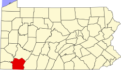
 Location of Henry Clay Township in Fayette County |
|
 Location of Fayette County in Pennsylvania |
|
| Country | United States |
| State | Pennsylvania |
| County | Fayette |
| Established | 1824-06-09 |
| Area | |
| • Total | 53.1 sq mi (137.4 km2) |
| • Land | 51.2 sq mi (132.7 km2) |
| • Water | 1.8 sq mi (4.7 km2) |
| Population (2010) | |
| • Total | 2,066 |
| • Density | 40/sq mi (15.6/km2) |
| Time zone | EST (UTC-4) |
| • Summer (DST) | EDT (UTC-5) |
| Area code(s) | 724 |
Henry Clay Township is a township in Fayette County, Pennsylvania, United States. The population was 2,066 at the 2010 census. The township was created June 9, 1824, from the eastern portion of Wharton Township. It is named for 19th-century American statesman Henry Clay. The northwestern corner of its territory was used to create Stewart Township on November 17, 1855. It is served by the Uniontown Area School District.
Unincorporated communities located within the township include Flat Rock, Fiketown, and Elk Park.
Henry Clay Township is in the southeast corner of Fayette County. It is bordered by Stewart Township to the north, Lower Turkeyfoot Township in Somerset County to the northeast, the borough of Confluence and Addison Township in Somerset County to the east, and Wharton Township to the west. To the south, it borders both West Virginia and Maryland. The borough of Markleysburg is in the southern part of the township but is a separate municipality.
According to the United States Census Bureau, the township has a total area of 53.1 square miles (137.4 km2), of which 51.2 square miles (132.7 km2) is land and 1.8 square miles (4.7 km2), or 3.41%, is water. The Youghiogheny River forms the eastern border of the township, which is the border with Somerset County.
...
Wikipedia
