Henning, Tennessee
| Henning, Tennessee | |
|---|---|
| Town | |
 |
|
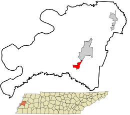
 Location in Lauderdale County and the state of Tennessee. |
|
| Coordinates: 35°40′25″N 89°34′39″W / 35.67361°N 89.57750°WCoordinates: 35°40′25″N 89°34′39″W / 35.67361°N 89.57750°W | |
| Country | United States |
| State | Tennessee |
| County | Lauderdale |
| Area | |
| • Total | 1.3 sq mi (3.3 km2) |
| • Land | 1.3 sq mi (3.3 km2) |
| • Water | 0.0 sq mi (0.0 km2) |
| Elevation | 292 ft (89 m) |
| Population (2010) | |
| • Total | 945 |
| • Density | 752.3/sq mi (290.5/km2) |
| Time zone | Central (CST) (UTC-6) |
| • Summer (DST) | CDT (UTC-5) |
| ZIP code | 38041 |
| Area code(s) | 731 |
| FIPS code | 47-33360 |
| GNIS feature ID | 1287426 |
Henning is a town in Lauderdale County, Tennessee. The population was 945 at the 2010 census.
The infamous Battle of Fort Pillow, a Civil War victory for the Confederates, took place near Henning. Here, nearly 200 black and white troops serving in the Union Army were killed by Confederates under the command of General Nathan Bedford Forrest.
Henning is located at 35°40′25″N 89°34′39″W / 35.67361°N 89.57750°W (35.673563, -89.577366).
According to the United States Census Bureau, the town has a total area of 1.3 square miles (3.4 km2), all land.
Henning is situated on the southeastern edge of the New Madrid Seismic Zone, an area with a high earthquake risk.
As of the census of 2000, there were 970 people, 362 households, and 238 families residing in the town. The population density was 752.3 people per square mile (290.3/km²). There were 406 housing units at an average density of 314.9 per square mile (121.5/km²). The racial makeup of the town was 22.37% White, 74.85% African American, 1.34% Native American, and 1.44% from two or more races. Hispanic or Latino of any race were 0.41% of the population.
...
Wikipedia
