Henbury
| Henbury | |
|---|---|
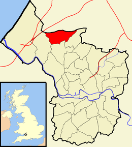
 Boundaries of the city council ward, shown within Bristol. |
|
| Henbury shown within Bristol | |
| Population | 10,699 (2011.Ward) |
| OS grid reference | ST564786 |
| Unitary authority | |
| Ceremonial county | |
| Region | |
| Country | England |
| Sovereign state | United Kingdom |
| Post town | BRISTOL |
| Postcode district | BS10 |
| Dialling code | 0117 |
| Police | Avon and Somerset |
| Fire | Avon |
| Ambulance | South Western |
| EU Parliament | South West England |
| UK Parliament | |
Henbury is a suburb of Bristol, England, approximately 5 miles (8.0 km) north west of the city centre. It was formerly a village in Gloucestershire and is now bordered by Westbury-on-Trym to the south; Brentry to the east and the Blaise Castle estate, Blaise Hamlet and Lawrence Weston to the west. To the north lie the South Gloucestershire village of Hallen and the entertainment/retail park Cribbs Causeway.
The Hazel Brook (also known as the Hen), a tributary of the River Trym, flows through Henbury and crosses Henbury Road in a small ford near The Salutation pub. The ford floods relatively often and a small bridge exists to allow traffic to pass, situated a few metres away.
Henbury is also the name of a council ward for Bristol City Council that includes both Henbury and Brentry.
Henbury Golf Club sits on the south border.
Henbury was first mentioned in 692 as Heanburg. The name is from the Old English hēan byrig, meaning 'high fortified place'. It was mentioned in the Domesday Book as Henberie.
Henbury was historically a very large parish. It extended to the River Severn and included King's Weston, Lawrence Weston, Charlton, Easter Compton, Pilning, Northwick and Aust. When the civil parish was created in 1866, parts of the ancient parish were separated to form the civil parishes of Redwick and Northwick (later Pilning and Severn Beach) and Aust.
...
Wikipedia
