Hemer
| Hemer | ||
|---|---|---|

Haus Hemer
|
||
|
||
| Coordinates: 51°23′0″N 07°46′0″E / 51.38333°N 7.76667°ECoordinates: 51°23′0″N 07°46′0″E / 51.38333°N 7.76667°E | ||
| Country | Germany | |
| State | North Rhine-Westphalia | |
| Admin. region | Arnsberg | |
| District | Märkischer Kreis | |
| Government | ||
| • Mayor | Michael Heilmann (UWG) | |
| Area | ||
| • Total | 67.56 km2 (26.09 sq mi) | |
| Elevation | 208 m (682 ft) | |
| Population (2015-12-31) | ||
| • Total | 33,535 | |
| • Density | 500/km2 (1,300/sq mi) | |
| Time zone | CET/CEST (UTC+1/+2) | |
| Postal codes | 58675 | |
| Dialling codes | 02372 | |
| Vehicle registration | MK | |
| Website | www.hemer.de | |
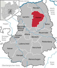
Hemer is a town in the Märkischer Kreis (District), in North Rhine-Westphalia, Germany.
Hemer is located at the north end of the Sauerland near the Ruhr river. The highest elevation, at 546 metres (1,791 ft), is in the Balver Wald in the south of the city. The lowest elevation, at 160 metres (525 ft), is at the Edelburg in the northeast.
Burial mounds show that around 1250 BC, Bronze Age shepherds and farmers lived in the area. Graves from the time of the Merovingian Franks around the year 650 were found near the present city centre.
Hemer was first mentioned in 1072 by its old name Hademare in a document of bishop Anno II of Cologne, granting lands to the newly founded Benedictine Grafschaft Abbey, including St. Vitus' church and two farms, the later Haus Hemer and the Hedhof. In 1124 the parish of St. Vitus was separated from the parish of Menden.
Hemer remained an unimportant settlement without market rights, even when the Counts of the Mark gained independence from the episcopal state of Cologne in the 13th century, when Hemer found itself on the boundary of the two states. But despite the political insignificance of the Kirchspiel Hemer ("Hemer parish"), it was already quite densely settled, thanks to its location on the old road from the Rhineland to Middle Germany (now Bundesstrasse 7), and to the iron mining and smelting industries already developed here. The boundary with Cologne, formed by the valley of the Hönne river southeast of Hemer, was protected by Klusenstein Castle, built in 1353. Local government in the parish of Hemer was the responsibility of the "Amt" of Iserlohn until 1647, when it was transferred to the family of Wachtendonk, who owned Haus Hemer at that time.
...
Wikipedia


