
Helmstedt
| Helmstedt | ||
|---|---|---|

Juleum Novum, building of the former University of Helmstedt
|
||
|
||

Helmstedt
|
||
|
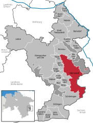
Location of Helmstedt within Helmstedt district
  |
||
| Coordinates: 52°13′41″N 11°00′38″E / 52.22806°N 11.01056°ECoordinates: 52°13′41″N 11°00′38″E / 52.22806°N 11.01056°E | ||
| Country | Germany | |
| State | Lower Saxony | |
| District | Helmstedt | |
| First mentioned | 952 | |
| Government | ||
| • Mayor | Heinz-Dieter Eisermann (Ind.) | |
| Area | ||
| • Total | 46.97 km2 (18.14 sq mi) | |
| Population (2015-12-31) | ||
| • Total | 23,254 | |
| • Density | 500/km2 (1,300/sq mi) | |
| Time zone | CET/CEST (UTC+1/+2) | |
| Postal codes | 38350 | |
| Dialling codes | 05351 | |
| Vehicle registration | HE | |
| Website | www.stadt-helmstedt.de | |

Helmstedt (German pronunciation: [ˈhɛlmˌʃtɛt]) is a town on the eastern edge of the German state of Lower Saxony. It is the capital of the District of Helmstedt. The historic university and Hanseatic city conserves an important monumental heritage of Romanesque and Renaissance buildings, as well as numerous timber framed houses. During the German partition the nearby Bundesautobahn 2 was the site of the Helmstedt–Marienborn border crossing, the most important on the former inner German border as starting point of the shortest land route between West Germany and West Berlin.
Helmstedt is situated in a basin between the Elm and Lappwald hill ranges, at the transition area between the northern foothills of the Harz mountains and the North German Plain. It is surrounded by the Elm-Lappwald Nature Park. The town centre is located about 36 kilometres (22 mi) east of Braunschweig, 45 kilometres (28 mi) west of Magdeburg, and 90 kilometres (56 mi) east of the state capital Hanover.
The municipal area includes the localities of Barmke and Emmerstedt, both incorporated by a 1974 administrative reform, as well as the resort town of Bad Helmstedt, about 3.5 kilometres (2.2 mi) east of the town centre. Helmstedt currently has about 23,000 inhabitants (2013).
...
Wikipedia