Heiligenblut (Carinthia)
| Heiligenblut am Großglockner | ||
|---|---|---|

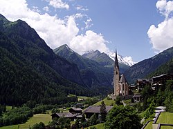
St Vincent Church and Grossglockner
|
||
|
||
| Location within Austria | ||
| Coordinates: 47°2′29″N 12°50′13″E / 47.04139°N 12.83694°ECoordinates: 47°2′29″N 12°50′13″E / 47.04139°N 12.83694°E | ||
| Country | Austria | |
| State | Carinthia | |
| District | Spittal an der Drau | |
| Government | ||
| • Mayor | Josef Schachner (ÖVP) | |
| Area | ||
| • Total | 193.15 km2 (74.58 sq mi) | |
| Elevation | 1,288 m (4,226 ft) | |
| Population (1 January 2016) | ||
| • Total | 1,022 | |
| • Density | 5.3/km2 (14/sq mi) | |
| Time zone | CET (UTC+1) | |
| • Summer (DST) | CEST (UTC+2) | |
| Postal code | 9844 | |
| Area code | 04824 | |
| Vehicle registration | SP | |
| Website | www.heiligenblut.at | |
Heiligenblut am Großglockner (Slovene: Sveta Kri, English: Holy Blood by the Großglockner) is a municipality in the district of Spittal an der Drau in Carinthia, Austria. The municipal area comprises the Katastralgemeinden of Apriach, Hof, Rojach, and Zlapp.
At the northwestern edge of Carinthia and bordering East Tyrol and Salzburg state, Heiligenblut is in a high valley of the Hohe Tauern range of the European Alps at the foot of the Grossglockner, the highest mountain in Austria, and of the Pasterze Glacier. Other peaks include the Johannisberg and the Fuscherkarkopf in the north, both part of the Alpine divide and accordingly on the Carinthia-Salzburg border.
The municipality is also the southern starting point of the scenic Grossglockner High Alpine Road to Bruck in the state of Salzburg, the former Hochtor Pass, today the continuation of the B107 highway from Lienz in East Tyrol. Nearby attractions include the Heiligenblut-Roßbach-Schareck cable car up to 2,606 m (8,550 ft), an open-air museum, the Stockmühlen mills in Apriach with nine flume mills, Lake Kachelsee to the west, the Möll, Gößnitz and Leiter waterfalls, the Margaritzen reservoir, and Lake Sandersee.
The construction of the nearby railway tunnel to the Fleißalm mountain area at 1,798 m (5,899 ft) is unique in Europe. The 1.6 km-long (1-mile) tunnel is filled with water during the summer but serves as a railway tunnel leading to the Fleißalm winter sports region in winter.
...
Wikipedia


