Hefersweiler
| Hefersweiler | ||
|---|---|---|
|
||
| Coordinates: 49°36′15″N 7°41′14″E / 49.60417°N 7.68722°ECoordinates: 49°36′15″N 7°41′14″E / 49.60417°N 7.68722°E | ||
| Country | Germany | |
| State | Rhineland-Palatinate | |
| District | Kusel | |
| Municipal assoc. | Lauterecken-Wolfstein | |
| Government | ||
| • Mayor | Bernd Degen | |
| Area | ||
| • Total | 7.20 km2 (2.78 sq mi) | |
| Elevation | 230 m (750 ft) | |
| Population (2015-12-31) | ||
| • Total | 521 | |
| • Density | 72/km2 (190/sq mi) | |
| Time zone | CET/CEST (UTC+1/+2) | |
| Postal codes | 67753 | |
| Dialling codes | 06363 | |
| Vehicle registration | KUS | |
| Website | www.hefersweiler-berzweiler.de | |
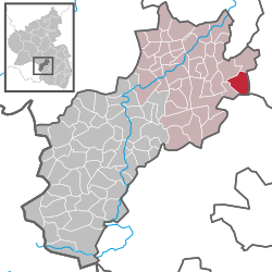
Hefersweiler is an Ortsgemeinde – a municipality belonging to a Verbandsgemeinde, a kind of collective municipality – in the Kusel district in Rhineland-Palatinate, Germany. It belongs to the Verbandsgemeinde Lauterecken-Wolfstein.
The municipality lies on the Odenbach in the North Palatine Uplands. Both its Ortsteile lie in this river’s valley at an elevation of some 225 m above sea level, Hefersweiler (main centre) up the valley on both sides of the river and Berzweiler farther down, mainly on the right bank. The Ahlbornerhof (homestead) lies across the Odenbach from Berzweiler on the left bank. The mountains either side of the valley reach more than 350 m above sea level (Reiterberg 364 m, Gründling 353 m). The municipal area measures 721 ha, of which roughly 20 ha is settled and 71 ha is wooded.
Hefersweiler borders in the north on the municipality of Nußbach, in the east on the municipalities of Rathskirchen and Seelen, in the south on the municipality of Niederkirchen, in the southwest on the municipality of Relsberg and in the northwest on the municipality of Reipoltskirchen.
Hefersweiler’s Ortsteile are Hefersweiler and Berzweiler. Also belonging to Hefersweiler is the outlying homestead of Ahlbornerhof.
The thickest part of Hefersweiler’s built-up area stretches along the crossing of the road through the Odenbach valley (Talstraße) and those that branch off towards Wolfstein, Relsberg and Seelen. In the village core stands Hefersweiler’s former schoolhouse. Berzweiler’s built-up area stretches mainly eastwards of the road and the Odenbach, partly in the valley of a small brook flowing down from the Berzweiler Heights, and partly along a path that leads towards Rudolphskirchen. The graveyard lies between the two Ortsteile at Berzweiler’s south end. Outstanding buildings on the valley road in the Ortsteil of Hefersweiler are the former schoolhouse built in 1903 and a building with particularly attractive walling around the door from 1574.
...
Wikipedia


