Hebersham, New South Wales
|
Hebersham Sydney, New South Wales |
|||||||||||||
|---|---|---|---|---|---|---|---|---|---|---|---|---|---|

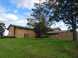
LDS Church on Pringle Road
|
|||||||||||||
| Coordinates | 33°45′10″S 150°59′00″E / 33.7527°S 150.9833°ECoordinates: 33°45′10″S 150°59′00″E / 33.7527°S 150.9833°E | ||||||||||||
| Population | 5,438 (2011 census) | ||||||||||||
| Postcode(s) | 2770 | ||||||||||||
| Location | 47 km (29 mi) W of Sydney CBD | ||||||||||||
| LGA(s) | City of Blacktown | ||||||||||||
| State electorate(s) | Mount Druitt | ||||||||||||
| Federal Division(s) | Chifley | ||||||||||||
|
|||||||||||||
Hebersham is a suburb of Sydney, in the state of New South Wales, Australia. Hebersham is located 47 kilometres west of the Sydney central business district, in the local government area of the City of Blacktown and is part of the Greater Western Sydney region.
Hebersham was coined to honour the Anglican Bishop Reginald Heber of Calcutta whose diocese included New South Wales. In 1829 the Trustees of the Clergy and Schools Lands in New South Wales planned to establish a village named Hebersham on the Western Highway, west of Eastern Creek. This never happened, but the name was used for this present day suburb.
At the 2011 census, there were 5,438 residents in Hebersham. 6.7% of people were Aboriginal or Torres Strait Islanders and this was more than double the national average of 2.5%. The majority of people were born in Australia, with the top other countries of birth being Philippines 4.8%, New Zealand 4.2% and Fiji 3.8%. About a third of people spoke a language other than English at home. Other languages spoken at home included Hindi 4.0%, Arabic 3.7%, Samoan 3.7%, Tagalog 2.7% and Urdu 2.7%.
Hebersham is also home to Hebersham Public School, a primary school founded in 1972.
...
Wikipedia

