Heathcote River
| Heathcote River | |
|---|---|

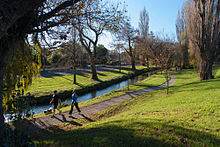
Heathcote River downstream of Barrington Street
|
|
| Country | New Zealand |
| Basin features | |
| River mouth |
Pegasus Bay via the Avon Heathcote Estuary 0 m (0 ft) |
The Heathcote River (Māori: Ōpāwaho) lies within the city boundaries of Christchurch, New Zealand, and is fed from springs near Templetons Road and also receives wet weather flows from as far west as Pound Road. It meanders around the base of the Port Hills from west to south-east.
The catchment of the Heathcote River extends to the suburb of Yaldhurst. It drains an area of approximately 100 square kilometres (39 sq mi), with the Cashmere Stream the largest tributary. It flows through Wigram, Hillmorton (where the main springs are located), Hoon Hay (and from there around the base of the Port Hills), Spreydon, Cracroft, Cashmere, Beckenham, St Martins, Opawa, Woolston and Ferrymead.
It drains into the Avon Heathcote Estuary before draining into Pegasus Bay.
The original name of this river, Ō-pa-waho means 'The Place of the Outward Pā', or 'The Outpost' and refers to this pā being an outpost (Māori: waho) of Kaiapoi. The pā was built in a higher location just downstream of the present Opawa Road Bridge. It was a resting place for Ngāi Tahu travelling between Kaiapoi and Horomaka (Banks Peninsula). The surrounding area was an important mahinga kai, a source of plentiful food, especially tuere (blind eel) and kanakana (lamprey).
...
Wikipedia
