Hazlet, New Jersey
| Hazlet, New Jersey | |
|---|---|
| Township | |
| Township of Hazlet | |

North Centerville section of the township
|
|
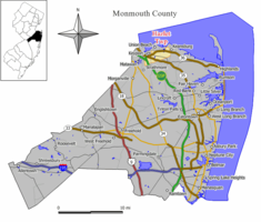
 Map of Hazlet Township in Monmouth County. Inset: Location of Monmouth County in the State of New Jersey. |
|
 Census Bureau map of Hazlet, New Jersey |
|
| Coordinates: 40°25′32″N 74°10′07″W / 40.425627°N 74.16869°WCoordinates: 40°25′32″N 74°10′07″W / 40.425627°N 74.16869°W | |
| Country |
|
| State |
|
| County | Monmouth |
| Incorporated | February 25, 1848 as Raritan Township |
| Renamed | November 28, 1967 as Hazlet Township |
| Named for | Dr. John Hazlett |
| Government | |
| • Type | Township |
| • Body | Township Committee |
| • Mayor | Scott Aagre (R, term ends December 31, 2016) |
| • Administrator | Dennis Pino |
| • Clerk | Evelyn A. Grandi |
| Area | |
| • Total | 5.675 sq mi (14.698 km2) |
| • Land | 5.557 sq mi (14.392 km2) |
| • Water | 0.118 sq mi (0.306 km2) 2.08% |
| Area rank | 265th of 566 in state 19th of 53 in county |
| Elevation | 33 ft (10 m) |
| Population (2010 Census) | |
| • Total | 20,334 |
| • Estimate (2015) | 20,097 |
| • Rank | 127th of 566 in state 10th of 53 in county |
| • Density | 3,659.4/sq mi (1,412.9/km2) |
| • Density rank | 174th of 566 in state 18th of 53 in county |
| Time zone | Eastern (EST) (UTC-5) |
| • Summer (DST) | Eastern (EDT) (UTC-4) |
| ZIP code | 07730 |
| Area code(s) | 732 |
| FIPS code | 3402530690 |
| GNIS feature ID | 0882120 |
| Website | www |
Hazlet is a township in Monmouth County, New Jersey, United States. As of the 2010 United States Census, the township's population was 20,334, reflecting a decline of 1,044 (-4.9%) from the 21,378 counted in the 2000 Census, which had in turn declined by 598 (-2.7%) from the 21,976 counted in the 1990 Census.
Hazlet is part of the Bayshore Regional Strategic Plan, an effort by nine municipalities in northern Monmouth County to reinvigorate the area's economy by emphasizing the traditional downtowns, dense residential neighborhoods, maritime history, and the natural beauty of the Raritan Bayshore coastline.
What is now Hazlet Township was originally incorporated as Raritan Township by an act of the New Jersey Legislature on February 25, 1848, from portions of Middletown Township. Portions of the township were taken to form Holmdel Township (February 23, 1857), Matawan Township (also February 23, 1857, now Aberdeen Township), Keyport (March 17, 1870), Keansburg (March 26, 1917) and Union Beach (March 16, 1925). The township was renamed "Hazlet Township" as of November 28, 1967, based on the results of a referendum held on November 7, 1967. Hazlet derives its name from Dr. John Hazlett, who had an estate in Raritan Township near the Keyport-Holmdel Turnpike, now Holmdel Road.
Hazlet was the site of the last drive-in movie theater in New Jersey, the Route 35 Drive-In, which closed in 1991, until the Delsea Drive-In in Vineland reopened in 2004.
...
Wikipedia
