Hazerswoude-Dorp
| Hazerswoude-Dorp | |
|---|---|
| Village | |

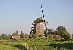
The Rietveldse Molen (Windmill of Rietveld) in the rural part of Hazerswoude.
|
|
 |
|
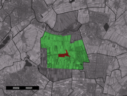
 The town centre (red) and the statistical district (light green) of Hazerswoude-Dorp in the former municipality of Rijnwoude. |
|
| Coordinates: 52°5′46″N 4°35′16″E / 52.09611°N 4.58778°ECoordinates: 52°5′46″N 4°35′16″E / 52.09611°N 4.58778°E | |
| Country | Netherlands |
| Province | South Holland |
| Municipality | Alphen aan den Rijn |
| Population (2007) | |
| • Total | 5,767 |
| Time zone | CET (UTC+1) |
| • Summer (DST) | CEST (UTC+2) |
Hazerswoude-Dorp is a town in the west of the Netherlands. It is located in the municipality of Alphen aan den Rijn, South Holland, about 7 km southwest of the town of Alphen aan den Rijn.
In 2001, the town of Hazerswoude-Dorp had 4292 inhabitants. The built-up area of the town was 0.76 km², and contained 1600 residences. The statistical area "Hazerswoude-Dorp", which also can include the peripheral parts of the village, as well as the surrounding countryside, has a population of around 5760.
...
Wikipedia
