Hayden Lake
| Hayden Lake, Idaho | |
|---|---|
| City | |
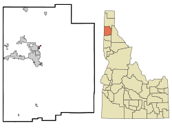
 Location in Kootenai County and the state of Idaho |
|
| Location in the United States | |
| Coordinates: 47°45′53″N 116°45′21″W / 47.76472°N 116.75583°WCoordinates: 47°45′53″N 116°45′21″W / 47.76472°N 116.75583°W | |
| Country | United States |
| State | Idaho |
| County | Kootenai |
| Area | |
| • Total | 0.68 sq mi (1.76 km2) |
| • Land | 0.59 sq mi (1.53 km2) |
| • Water | 0.09 sq mi (0.23 km2) |
| Elevation | 2,287 ft (697 m) |
| Population (2010) | |
| • Total | 574 |
| • Estimate (2016) | 614 |
| • Density | 973/sq mi (375.6/km2) |
| Time zone | Pacific (PST) (UTC-8) |
| • Summer (DST) | PDT (UTC-7) |
| ZIP code | 83835 |
| Area code(s) | 208 |
| FIPS code | 16-36460 |
| GNIS feature ID | 0396631 |
Hayden Lake is both a city and a lake in Kootenai County, Idaho, United States. Located in the northern portion of the state, it is considered a suburb of Coeur d'Alene. Its population was 574 at the 2010 census. Hayden Lake is one of several natural lakes in northern Idaho; its shoreline is heavily populated with homes and it has limited public access.
The actual city of Hayden Lake, ID is located around the Hayden Lake Country Club and a small portion of the northern part of the lake. Most of the lake is surrounded by the city of Hayden, ID. The shores of the lake are filled with summer cabins to large mansions and the historic Hayden Lake Country Club lies at the center of the community.
Hayden Lake is located at 47°45′53″N 116°45′21″W / 47.76472°N 116.75583°W (47.764720, -116.755931).
According to the United States Census Bureau, the city has a total area of 0.68 square miles (1.76 km2), of which 0.59 square miles (1.53 km2) is land and 0.09 square miles (0.23 km2) is water.
Hayden Lake Stats:
Hayden Lake, like Lake Coeur d'Alene and other lakes surrounding the Spokane Valley and Rathdrum Prairie, was formed by the Missoula Floods, most recently 12,000 to 15,000 years ago. The Purcell Lobe of the Cordilleran Ice Sheet flowed south from Canada, carving the basin of present-day Lake Pend Oreille and damming the Clark Fork river. The impounded river repeatedly filled to form Glacial Lake Missoula and broke through the ice dam, resulting in massive floods that filled the Rathdrum Prairie area with sand, gravel, and boulders. Large eddy bars formed downstream from bedrock obstructions, thereby damming tributary valleys and creating lakes.
...
Wikipedia

