Hawsha
| Hawsha | |
|---|---|

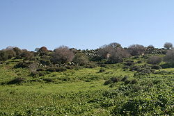
Remains of Hawsha in the winter of 2010
|
|
| Arabic | هوشة |
| Name meaning | Joshua or Kh. Husheh; "The ruin of Husheh", |
| Also spelled | Husha, Khirbat Husha, Khǔrbet Hǔsheh |
| Subdistrict | Haifa |
| Coordinates | 32°47′33″N 35°08′37″E / 32.79250°N 35.14361°ECoordinates: 32°47′33″N 35°08′37″E / 32.79250°N 35.14361°E |
| Palestine grid | 163/244 |
| Population | 580 (400 Arabs, 180 Jews) (1945) |
| Area | 901 (all but 7 dunums was owned by Jews by 1944-45) dunams 0.9 km² |
| Date of depopulation | mid-April, 1948 |
| Cause(s) of depopulation | Military assault by Yishuv forces |
Hawsha (Arabic: هوشة, Hǔsheh, also Husha) was a Palestinian village located 13 kilometers (8.1 mi) east of Haifa, about 100 meters (330 ft) above sea level. It contained a maqam (shrine) for Nabi Hushan, and a number of ancient ruins, including rock-cut tombs, and a mosaic floor.
In 1945, it had a population of 580 inhabitants, 400 of whom were Arab Muslims and 180 of whom were Jewish. The built-up area of the village was 50 dunums, and 717 dunums were used for agriculture. All but 7 dunums of public land were owned by Jews by this time.
Hawsha was depopulated during the 1947–1948 Civil War in Mandatory Palestine on April 16, 1948 as part of the Battle of Ramat Yohanan.
The village was located on a low hilly area between the plain of Haifa and Marj ibn Amr (Jezreel Valley) and situated on an east-west axis. To the west, lay a wide valley (Wadi Husheh) that was the dividing area between it and the neighboring village of Khirbat al-Kasayir.Leopold Zunz, and researchers from the Palestine Exploration Fund (PEF), among others, have connected Hawsha to the biblical village of Usha, a border settlement of the Israelite tribe of Asher (Book of Joshua 29:19) and the seat of the Sanhedrin after 135 AD.
...
Wikipedia

