Hawridge
| Hawridge | |
|---|---|
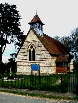
 St Mary's Church, Hawridge |
|
| Hawridge shown within Buckinghamshire | |
| OS grid reference | SP950060 |
| • London | 27 miles |
| Civil parish | |
| District | |
| Shire county | |
| Region | |
| Country | England |
| Sovereign state | United Kingdom |
| Post town | Chesham |
| Postcode district | HP5 |
| Dialling code | 01494 |
| EU Parliament | South East England |
| UK Parliament | |
| Website | [1] |
Hawridge, (recorded as Hoquerug in the 12th century) is a small village in the Chilterns in the county of Buckinghamshire, England and bordering the county boundary with Hertfordshire. It is 3 miles (4.8 km) from Chesham, 4 miles (6.4 km) from both Tring and Berkhamsted. Hawridge is one of four villages comprising Cholesbury-cum-St Leonards, a civil parish within Chiltern District.
It is a rural community but the agricultural economy is small and most local people rely for employment on neighbouring towns, the proximity of London, the availability of broadband technology or local tourism and the popularity of the area for recreational activities.
Before the incorporation of additional land from adjacent parishes, Hawridge historically comprised some 696 acres (2.82 km2). It is located in the main along a ridge on the dip slope within the Chiltern downland landscape. It is some 590 ft (182 m) above sea level.
The geology of the area has dictated the land use. The soil comprises gravely clay, intermixed with flints, small pebbles, and öolite over a chalk formation. Several examples of puddingstones a characteristic form of this aggregate have been found locally. There are no streams in the area due to the porous chalk sub soil. In places the occurrence of clay close to the surface accounts for several natural ponds fed by springs. Until connection with mains water in the mid-20th century, the scarcity of water had necessitated the sinking of deep wells and capture of rainwater.
In contrast to nearby areas of the Chilterns more land is given over to open space i.e. agricultural, both arable and pasture; paddocks; heathland and most significantly the Common along one side of which the majority of houses are arranged. There is relatively little mature ancient woodland remaining as most was cleared mainly during the 18th century and given over to beech plantation connected with the furniture making industry in High Wycombe. Both chalk and a small amount of clay have been extracted over the years, Meanwhile, in more recent times flint was dug out for road making. Both activities have left their mark in the form of small mounds and shallow depressions.
...
Wikipedia

