Hawaii Route 36
| Hāna Highway | |||||||
|---|---|---|---|---|---|---|---|
| Hāna Millennium Legacy Trail | |||||||
| Route information | |||||||
| Maintained by HDOT | |||||||
| Length | 64.40 mi (103.64 km) | ||||||
| Component highways |
|
||||||
| Major junctions | |||||||
| West end |
|
||||||
| East end |
|
||||||
| Location | |||||||
| Counties | Maui | ||||||
| Highway system | |||||||
|
|||||||
|
Hāna Belt Road
|
|

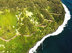
Aerial view of the Hāna Highway
|
|
| Nearest city | Makawao, Hawaii |
|---|---|
| Coordinates | 20°53′52″N 156°13′20″W / 20.89778°N 156.22222°W |
| Area | 153 acres (62 ha) |
| Built | 1900 |
| Architectural style | Basalt arch, et al. |
| NRHP reference # | 01000615 |
| Added to NRHP | June 15, 2001 |
The Hāna Highway is a 64.4-mile-long (103.6 km) stretch of Hawaii Routes 36 and 360 which connects Kahului with the town of Hāna in east Maui. On the east after Kalepa Bridge, the highway continues to Kīpahulu as Hawaii Route 31 (the Piilani Highway). Although Hāna is only about 52 miles (84 km) from Kahului, it takes about 2.5 hours to drive when no stops are made as the highway is very winding and narrow and passes over 59 bridges, 46 of which are only one lane wide. There are approximately 620 curves along Route 360 from just east of Kahului to Hāna, almost all of it through lush, tropical rainforest. Many of the concrete and steel bridges date back to 1910 and all but one are still in use. That one bridge, badly damaged by erosion, has been replaced by a portable steel ACROW bridge erected by the United States Army Corps of Engineers.
In August 2000, the highway was designated as the Hāna Millennium Legacy Trail by President Bill Clinton, with the trail start designated in Pāʻia. The Hāna Highway was listed on the National Register of Historic Places on June 15, 2001.
...
Wikipedia


