Havensville, Kansas
| Havensville, Kansas | |
|---|---|
| City | |

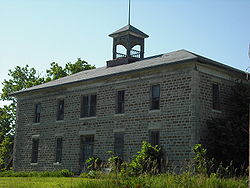
Historic Havensville School (2009)
|
|
 Location within Pottawatomie County and Kansas |
|
 KDOT map of Pottawatomie County (legend) |
|
| Coordinates: 39°30′38″N 96°4′38″W / 39.51056°N 96.07722°WCoordinates: 39°30′38″N 96°4′38″W / 39.51056°N 96.07722°W | |
| Country | United States |
| State | Kansas |
| County | Pottawatomie |
| Area | |
| • Total | 0.15 sq mi (0.39 km2) |
| • Land | 0.15 sq mi (0.39 km2) |
| • Water | 0 sq mi (0 km2) |
| Elevation | 1,198 ft (365 m) |
| Population (2010) | |
| • Total | 133 |
| • Estimate (2016) | 150 |
| • Density | 890/sq mi (340/km2) |
| Time zone | Central (CST) (UTC-6) |
| • Summer (DST) | CDT (UTC-5) |
| ZIP code | 66432 |
| Area code | 785 |
| FIPS code | 20-30775 |
| GNIS feature ID | 0473442 |
Havensville is a city in Pottawatomie County, Kansas, United States. As of the 2010 census, the city population was 133.
Havensville had its start in the year 1878 by the building of the railroad through that territory. It was named for Paul E. Havens, a railroad employee.
The first post office in Havensville was established in March 1878.
Havensville is located at 39°30′38″N 96°4′38″W / 39.51056°N 96.07722°W (39.510473, -96.077360). According to the United States Census Bureau, the city has a total area of 0.15 square miles (0.39 km2), all of it land.
This climatic region is typified by large seasonal temperature differences, with warm to hot (and often humid) summers and cold (sometimes severely cold) winters. According to the Köppen Climate Classification system, Havensville has a humid continental climate, abbreviated "Dfa" on climate maps.
Havensville is part of the Manhattan, Kansas Metropolitan Statistical Area.
As of the census of 2010, there were 133 people, 58 households, and 41 families residing in the city. The population density was 886.7 inhabitants per square mile (342.4/km2). There were 73 housing units at an average density of 486.7 per square mile (187.9/km2). The racial makeup of the city was 98.5% White, 0.8% from other races, and 0.8% from two or more races. Hispanic or Latino of any race were 3.8% of the population.
...
Wikipedia
