Havasu Creek
| Havasu Creek | |
|
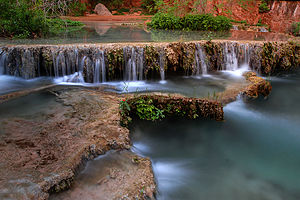
Travertine formations
|
|
| Name origin: ha “water” + vasu “blue-green” | |
| Country | United States |
|---|---|
| State | Arizona |
| County | Coconino |
| Source | Havasupai Indian Reservation |
| - location | Havasu Springs |
| - elevation | 3,260 ft (994 m) |
| - coordinates | 36°13′00″N 112°41′13″W / 36.21667°N 112.68694°W |
| Mouth | Colorado River |
| - location | Havasu Rapids, Grand Canyon |
| - elevation | 2,093 ft (638 m) |
| - coordinates | 36°18′28″N 112°45′43″W / 36.30778°N 112.76194°WCoordinates: 36°18′28″N 112°45′43″W / 36.30778°N 112.76194°W |
Havasu Creek is a stream in the U.S. state of Arizona associated with the Havasupai people. It is a tributary to the Colorado River, which it enters in the Grand Canyon.
Havasu Creek starts out above the canyon wall as a small trickle of snow run-off and rain water. This water meanders on the plains above the canyon for about 50 miles (80 km) until it enters Cataract Canyon (also known as Havasu Canyon). It then reaches Havasu Springs, where an underground source feeds the creek. This spring can be accessed by heading upstream when the creek is first encountered. The water stays at about 70 °F (21 °C) all year around. The creek is well known for its blue-green color and distinctive travertine formations. This is due to large amounts of calcium carbonate in the water that formed the limestone that lines the creek and reflects its color so strongly. This also gives the creek an interesting feature, as it is ever-changing. This occurs because any items that fall into the stream mineralize very quickly, causing new formations and changing the flow of the water. This causes the creek to never look the same from one year to another. The creek runs through the village of Supai, and it ultimately flows into the Colorado River.
Until the August 2008 flooding, Navajo Falls was the first prominent waterfall in the canyon. They were named after an old Supai chief. It was located 1.25 miles (2 km) from Supai and is accessed from a trail located on the left side (right side when heading upstream) of the main trail. This side trail leads down to the creek, where there is a crude bridge that crosses over the creek. The trail then leads back into the trees, where the main pool and falls were located. The pool was popular for its seclusion and its ease to swimmers. The falls were approximately 70 feet (21 m) tall and consisted of separate sets of water chutes, the main one located on the right side where the water cascaded down the canyon hill. To the left of the main chute there were other smaller ones that were steeper and more vertical. There were a few places that are viable for cliff jumping, although caution was necessary.
...
Wikipedia


