Hatteras Village
| Hatteras, North Carolina | |
|---|---|
| Census-designated place | |
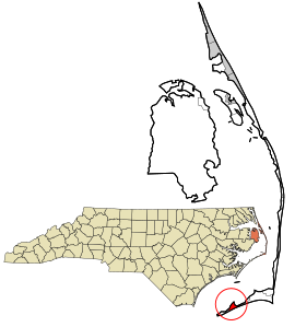
 Location in Dare County and the state of North Carolina |
|
| Coordinates: 35°13′10″N 75°41′25″W / 35.21944°N 75.69028°WCoordinates: 35°13′10″N 75°41′25″W / 35.21944°N 75.69028°W | |
| Country | United States of America |
| State | North Carolina |
| County | Dare |
| Named for | Hatteras Indians |
| Area | |
| • Total | 1.68 sq mi (4.36 km2) |
| • Land | 1.58 sq mi (4.08 km2) |
| • Water | 0.11 sq mi (0.29 km2) |
| Elevation | 3 ft (0.9 m) |
| Population (2010) | |
| • Total | 504 |
| • Density | 320/sq mi (123.6/km2) |
| ZIP code | 27943 |
Hatteras is an unincorporated village and census-designated place (CDP) in Dare County, North Carolina, United States, on the Outer Banks island of Hatteras, at its extreme southwestern tip. As of the 2010 census it had a population of 504. Immediately to the west of the village of Hatteras is Hatteras Inlet which separates Hatteras Island from the neighboring Ocracoke Island. North Carolina Highway 12 passes through the community linking it to Frisco to the east and Ocracoke to the west (via a ferry across Hatteras Inlet).
The residents of Hatteras are governed by the Dare County Board of Commissioners. Hatteras is part of District 4, along with Avon, Buxton, Frisco, Rodanthe, Waves and Salvo.
Hatteras is best known as a fishing and vacation destination. This community offers visitors ample opportunities for recreation, sightseeing, and remote relaxation especially on its beautiful beaches.
Watersports are plentiful on both the ocean-side and the sound-side of the village. Proximity to the convergence of the Labrador Current and the Gulf Stream result in the largest surf available on the East Coast. On the protected Pamlico Sound side of the island watersports such as windsurfing, kayaking, kiteboarding, and swimming are all readily available and accessible.
...
Wikipedia
