Hatford
| Hatford | |
|---|---|
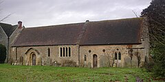
 St George's parish church |
|
| Hatford shown within Oxfordshire | |
| Population | 98 (2001 census) |
| OS grid reference | SU3394 |
| Civil parish |
|
| District | |
| Shire county | |
| Region | |
| Country | England |
| Sovereign state | United Kingdom |
| Post town | Faringdon |
| Postcode district | SN7 |
| Police | Thames Valley |
| Fire | Oxfordshire |
| Ambulance | South Central |
| EU Parliament | South East England |
| UK Parliament | |
Hatford is a village and civil parish of some 1,000 acres (400 ha) in the Vale of White Horse. It was part of Berkshire until the 1974 boundary changes transferred it to Oxfordshire.
As Hatford is so small it has almost no amenities, but the Community Bus Service from Stanford in the Vale provides regular transport to the nearby market towns of Faringdon and Wantage. Hatford has no village shop and no public house. There was an off-licence until the Second World War, until this received a direct hit from a German bomb (see below).
The sandstone soil is a rich source of sand and gravel. Sand has been extracted here for many years and it was during quarrying, between 1937 and 1958, that an early Iron Age settlement was discovered. The lane leading north out of the village is called Sandy Lane.
The earliest evidence of human habitation is a Bronze Age spearhead, found near the river Hat. Signs of an early Iron Age settlement have also been found and there is thought to have been at least one Roman villa, in fields next to the present village. Despite its long history, the population of Hatford has not changed much in size since the time of the Domesday Book, when it had some 120 residents.
Hatford has had two Anglican parish churches. The later of these, the church of the Holy Trinity (built in 1873–4 to a design by William Wigginton) became dilapidated and was finally deconsecrated and sold in 1972, for use as a private dwelling. The older Saint George's was reopened in the same year, reroofed in 1973 and reglazed in 1974; reinstated as Hatford's place of worship.
...
Wikipedia

