Haslital
|
Oberhasli Historically: Haslital, Hasele, Hasly im Wyssland |
||
|---|---|---|
| Talschaft | ||
|
||
 |
||
| Country |
|
|
| Canton |
|
|
| Region | Interlaken-Oberhasli | |
| Area | ||
| • Total | 551 km2 (213 sq mi) | |
| Population (2007) | ||
| • Total | 7,843 | |
| • Density | 14/km2 (37/sq mi) | |
| Time zone | CET (UTC+1) | |
| • Summer (DST) | CEST (UTC+2) | |
| Municipalities | 6 | |
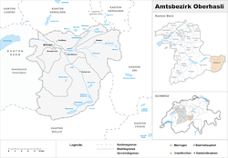
The Oberhasli district (or Haslital (Hasli Valley) while referring mainly to the major valley of the Aare) is a historical Landvogtei or Talschaft in the Bernese Highlands, Switzerland, bordering on the cantons of Obwalden (OW), Nidwalden (NW), Uri (UR) and Wallis (VS). However Haslital is a geographical term and designates only the major valley of the Aare and does not designate the many sidevalleys, such as the Gadmertal, Ürbachtal, Gental, Reichenbachtal. The local dialect is of the Highest Alemannic variety.
From 1833 to 2009, Oberhasli was incorporated as the Oberhasli district, the easternmost of the 26 districts of the canton of Bern, bordering the district of Interlaken to the west. Since 2010, Oberhasli and Interlaken have been administratively united as the administrative district Interlaken-Oberhasli.
With its area of 551 km², it is larger than the canton of Basel-Landschaft. It consists of the six municipalities of Gadmen, Guttannen, Hasliberg, Innertkirchen, Meiringen and Schattenhalb, with a total population of just below 8,000, corresponding to a population density of less than 15/km2 (compared to a Swiss average of 181/km2), due to a significant portion of the area of Oberhasli being uninhabitable High Alps.
...
Wikipedia

