Hasland
| Hasland | |
|---|---|
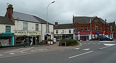
 Mansfield Road looking towards The Green. |
|
| Hasland shown within Derbyshire | |
| Population | 6,615 (Ward 2011) |
| OS grid reference | SK395698 |
| District | |
| Shire county | |
| Region | |
| Country | England |
| Sovereign state | United Kingdom |
| Post town | Chesterfield |
| Postcode district | S41 0xx |
| Dialling code | 01246 |
| Police | Derbyshire |
| Fire | Derbyshire |
| Ambulance | East Midlands |
| EU Parliament | East Midlands |
| UK Parliament | |
Hasland is a suburb in the south-east of Chesterfield, Derbyshire, England. Hasland is located South of Spital, East of Birdholme and North of Grassmoor. Hasland is a ward of the Borough of Chesterfield. The ward population at the 2011 Census was 6,615. The A617 (Hasland By-Pass) links Hasland, along with Chesterfield, to the M1. Historically a village, with many local residents continuing to refer to it as a village, it expanded greatly during the 20th century and now merges with Chesterfield itself.
The expansion of Hasland has created a dense array of shops and services, including: a theatre, three schools, two churches, two medical centres and a couple of industrial estates.
In 1913, Alderman Eastwood (Mayor of Chesterfield, 1905–1908) donated the park to the public in memory of his late father. The Deputy Mayor, Ald. C.P. Markham, showed enormous gratitude in accepting the gift: "Hasland is now set up for all time. It has got a very wide street and Ald. Eastwood has finished it off by giving one of the most handsome parks there will be in this part of the world". The first condition on donating the park was that it should be called "Hasland Park", however Eastwood later accepted the council's decision to name the park "Eastwood Park".
Eastwood Park was closed for over 6 months in September 2012, as part of a major restoration project. Chesterfield Borough Council received £1.07bn from the Heritage Lottery Fund and contributed a further £201. The original four-week closure was extended following complications in planning and construction work, partially due to flooding during early 2013. The restoration project includes improvements to the Hasland Village Hall and fountain, modernisation of play areas, a new sports pavilion and a new multi-use games area. The council also announced plans to rename the park to Eastwood Park, a Queen Elizabeth II Field, as part of the legacy of the Queen's Diamond Jubilee.
Mansfield Road, towards the South-East of Hasland, is home to a row of convenience and specialist shops. These include: a Post Office, petrol station, sweet shop, fish bar, Co-op, greengrocer, florist, bookmakers, and a computer repair shop. Because of the diversity of shops on Mansfield Road, there is little demand for shops elsewhere in Hasland and you can walk to Chesterfield town centre in no time at all.
...
Wikipedia

