Harvey Cedars, New Jersey
| Harvey Cedars, New Jersey | |
|---|---|
| Borough | |
| Borough of Harvey Cedars | |
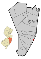
 Map of Harvey Cedars in Ocean County. Inset: Location of Ocean County highlighted in the State of New Jersey. |
|
 Census Bureau map of Harvey Cedars, New Jersey |
|
| Coordinates: 39°41′58″N 74°08′29″W / 39.699578°N 74.141511°WCoordinates: 39°41′58″N 74°08′29″W / 39.699578°N 74.141511°W | |
| Country |
|
| state |
|
| County | Ocean |
| Incorporated | November 20, 1894 |
| Government | |
| • Type | Walsh Act |
| • Body | Board of Commissioners |
| • Mayor | Jonathan S. Oldham (term ends December 31, 2019) |
| • Clerk | Daina Dale |
| Area | |
| • Total | 1.185 sq mi (3.070 km2) |
| • Land | 0.557 sq mi (1.444 km2) |
| • Water | 0.628 sq mi (1.626 km2) 52.97% |
| Area rank | 486th of 566 in state 21st of 33 in county |
| Elevation | 3 ft (0.9 m) |
| Population (2010 Census) | |
| • Total | 337 |
| • Estimate (2015) | 341 |
| • Rank | 559th of 566 in state 32nd of 33 in county |
| • Density | 604.6/sq mi (233.4/km2) |
| • Density rank | 427th of 566 in state 24th of 33 in county |
| Time zone | Eastern (EST) (UTC-5) |
| • Summer (DST) | Eastern (EDT) (UTC-4) |
| ZIP code | 08008 |
| Area code(s) | 609 exchanges: 207, 361, 492, 494 |
| FIPS code | 3402930390 |
| GNIS feature ID | 0885246 |
| Website | www |
Harvey Cedars is a borough in Ocean County, New Jersey, United States. As of the 2010 United States Census, the borough's population was 337, reflecting a decline of 22 (-6.1%) from the 359 counted in the 2000 Census, which had in turn declined by 3 (-0.8%) from the 362 counted in the 1990 Census. The borough borders the Atlantic Ocean on Long Beach Island.
Harvey Cedars was incorporated as a borough by an act of the New Jersey Legislature on December 15, 1894, from portions of Union Township (now Barnegat Township), based on the results of a referendum held on November 20, 1894.
The majority of the housing units in the borough are seasonal houses used primarily in the summer by owners who live elsewhere, bringing the summer population to 12,000. The borough's quiet character and bay and ocean access make housing very expensive, with bay or oceanfront houses priced at $2 million or more. Despite the borough's small size, its property was assessed at over $1.2 billion in 2014.
Before Long Beach Island was developed, its northern area, from the Barnegat Inlet to the Great Swamp (now Surf City), was covered with Atlantic white cedar (chamaecyparis thyoides). Early inhabitants of the area harvested salt hay (spartina patens) and seaweed to make a living.
The earliest reference to the area was a deed from 1751 that called the place "Harvest Quarters". The name "Harvey Cedars" may be a portmanteau derived from the combination of "harvest" housing used by these farmers and the "cedars" that grew in the area.
According to the United States Census Bureau, the borough had a total area of 1.185 square miles (3.070 km2), including 0.557 square miles (1.444 km2) of land and 0.628 square miles (1.626 km2) of water (52.97%).
...
Wikipedia
