Hartville, Missouri
| Hartville, Missouri | |
|---|---|
| City | |
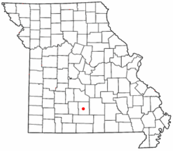
 Location of Hartville, Missouri |
|
| Coordinates: 37°15′1″N 92°30′43″W / 37.25028°N 92.51194°WCoordinates: 37°15′1″N 92°30′43″W / 37.25028°N 92.51194°W | |
| Country | United States |
| State | Missouri |
| County | Wright |
| Area | |
| • Total | 0.66 sq mi (1.71 km2) |
| • Land | 0.65 sq mi (1.68 km2) |
| • Water | 0.01 sq mi (0.03 km2) |
| Elevation | 1,191 ft (363 m) |
| Population (2010) | |
| • Total | 613 |
| • Estimate (2012) | 608 |
| • Density | 943.1/sq mi (364.1/km2) |
| Time zone | Central (CST) (UTC-6) |
| • Summer (DST) | CDT (UTC-5) |
| ZIP code | 65667 |
| Area code(s) | 417 |
| FIPS code | 29-30754 |
| GNIS feature ID | 0719185 |
Hartville is a city in Wright County, Missouri, United States. The population was 613 at the 2010 census. It is the county seat of Wright County.
A post office called Hartville has been in operation since 1842. The community has the name of Isaac Hart, a pioneer citizen.
Much of the town was destroyed in the Battle of Hartville in 1863. John Wimer, the seventh person to serve as mayor of St. Louis, was killed in the battle and buried at Hartville.
The Grovespring Tornado in 1959 destroyed most of Hartville's business district, as well as the post office. There were no major injuries because a warning alarm had been sounded.
Kelton House was listed on the National Register of Historic Places in 1983.
Hartville is located at 37°15′1″N 92°30′43″W / 37.25028°N 92.51194°W (37.250170, -92.511916), along the Wood's Fork of the Gasconade River. According to the United States Census Bureau, the city has a total area of 0.66 square miles (1.71 km2), of which, 0.65 square miles (1.68 km2) is land and 0.01 square miles (0.03 km2) is water.
...
Wikipedia
