Hartsdale, NY
| Hartsdale, New York | |
|---|---|
| CDP | |
 |
|
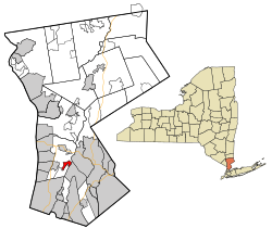
 Location of Hartsdale, New York |
|
| Coordinates: 41°2′N 73°48′W / 41.033°N 73.800°WCoordinates: 41°2′N 73°48′W / 41.033°N 73.800°W | |
| Country | United States |
| State | New York |
| County | Westchester |
| Area | |
| • Total | 0.9 sq mi (2.3 km2) |
| • Land | 0.9 sq mi (2.3 km2) |
| • Water | 0.0 sq mi (0.0 km2) |
| Elevation | 184 ft (56 m) |
| Population (2010) | |
| • Total | 5,293 |
| • Density | 6,000/sq mi (2,300/km2) |
| Time zone | Eastern (EST) (UTC-5) |
| • Summer (DST) | EDT (UTC-4) |
| ZIP code | 10530 |
| Area code(s) | 914 |
| FIPS code | 36-32523 |
| GNIS feature ID | 0952312 |
Hartsdale is a hamlet and a census-designated place (CDP) located in the town of Greenburgh, Westchester County, New York. The population was 5,293 at the 2010 census. It is a suburb of New York City.
Hartsdale is located at 41°2′N 73°48′W / 41.033°N 73.800°W (41.03, −73.80).
Major roads include NY 100 and the Bronx River Parkway. For mass transit to NYC, residents can take either Metro-North Railroad's Harlem Line or the Bee-Line Bus routes 1X, 3, 20, 21, and BxM4C. Bee-Line also provides local service on bus routes 34, 38, 39, 43, and 65.
According to the United States Census Bureau, the community has a total area of 0.9 square miles (2.3 km2), all land.
As of the census of 2000, there were 9,830 people, 4,314 households, and 2,756 families residing in the community. The population density was 3,068.0 per square mile (1,186.1/km²). There were 4,478 housing units at an average density of 1,397.6/sq mi (540.3/km²). The racial makeup of the community was 76.14% White, 8.71% African American, 0.19% Native American, 10.17% Asian, 0.04% Pacific Islander, 2.64% from other races, and 2.10% from two or more races. Hispanic or Latino of any race were 9.55% of the population.
...
Wikipedia
